
KANSAS CITY, MISSOURI — An Enhanced Risk has been issued for Saturday June 13 stretching from eastern Kansas through St. Louis, Missouri, with 75-plus mph wind gusts identified as the primary threat across a corridor that also carries a 5 percent tornado probability for northern Missouri including Kansas City and significant hail potential depending on storm mode.
Enhanced Risk Core Covers Kansas City Through St. Louis Saturday
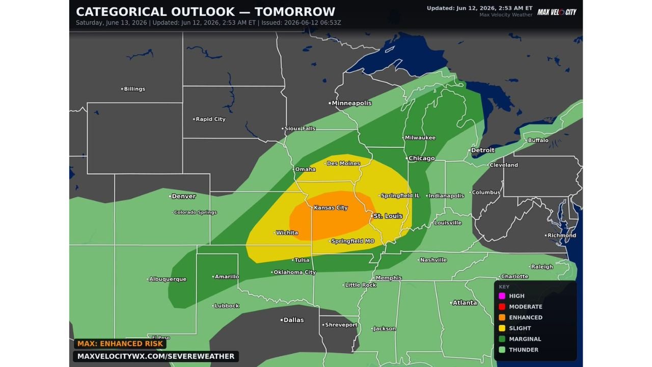
The Max Velocity categorical outlook updated June 12 at 2:53 AM ET shows an Enhanced Risk in orange centered directly over Kansas City, St. Louis, and the surrounding Missouri corridor. The Enhanced zone extends westward into eastern Kansas and Wichita while pushing eastward toward Springfield Illinois and Indianapolis.
A Slight Risk in yellow surrounds the Enhanced core, covering Des Moines, Omaha, Springfield Missouri, Tulsa, Oklahoma City, and the broader central plains region. Marginal Risk shading extends the severe weather footprint further outward across the upper Midwest and into portions of the South.
75 MPH Wind Gusts the Primary Threat With Tornadoes Also Possible
Forecasters are flagging severe wind gusts exceeding 75 mph as the dominant hazard with Saturday’s Enhanced Risk across the Kansas City and St. Louis corridor. Higher confidence lies in a linear storm mode which favors widespread damaging straight-line winds over the entire risk zone.
A 5 percent tornado probability has been drawn for northern Missouri including Kansas City, acknowledging that supercells remain possible before any linear consolidation occurs. Significant hail is also on the table depending on how storm mode ultimately evolves Saturday.
All Hazards Risk Requires Full Preparation Across Missouri and Kansas
The all-hazards nature of Saturday’s setup means residents across eastern Kansas, Missouri, and into Illinois need to prepare for multiple simultaneous threats. The combination of 75-plus mph winds, tornado potential, and significant hail across a densely populated corridor makes this a high-impact severe weather day for the region.
Residents across Kansas City, St. Louis, Wichita, and Springfield Missouri should have severe weather plans finalized before Saturday storms arrive.
Stay with GordonRamsayClub.com for the latest updates.

Leave a Reply