
MINNEAPOLIS, MINNESOTA — A complex and significant two-day severe weather pattern is underway across the Midwest, with multiple rounds of storms carrying the potential for all hazards including strong tornadoes and widespread damaging winds forecast for today and Thursday across a large portion of the central United States.
Enhanced Risk Zone Covers Major Midwest Cities Both Days
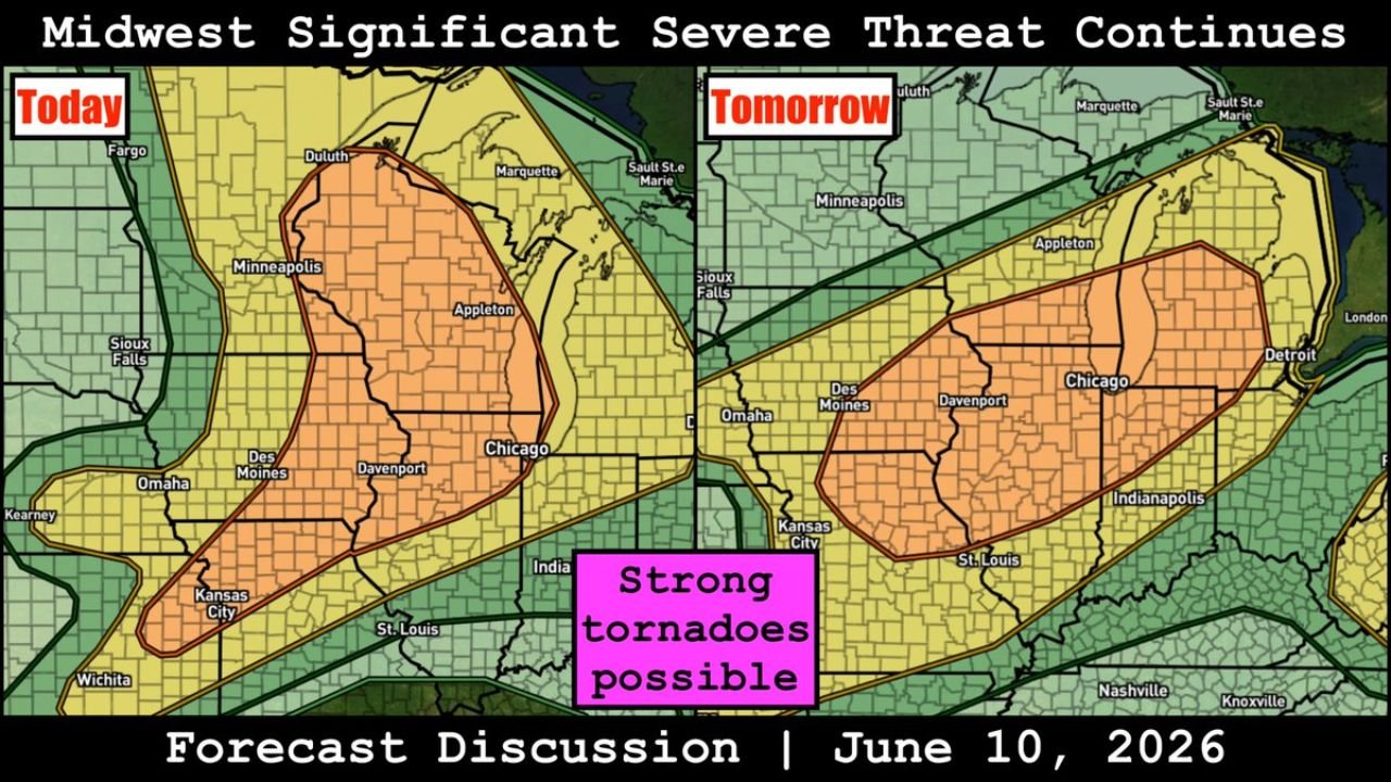
Today’s outlook places an Enhanced Risk corridor stretching from Minneapolis and Duluth southward through Des Moines, Davenport, Chicago, Kansas City, and St. Louis. The orange-shaded zone covers a broad swath of the upper and central Midwest with all severe hazards in play during today’s storm windows.
Thursday’s outlook shifts the Enhanced Risk zone eastward, keeping Chicago, Davenport, and Des Moines in the core while expanding coverage toward Omaha, Kansas City, St. Louis, Indianapolis, and Detroit. Strong tornadoes are explicitly possible across both day’s setups according to the forecast discussion graphic.
Strong Tornadoes Possible Across the Two Day Setup
Forecasters are highlighting strong tornadoes as a specific concern embedded within the broader severe weather pattern. The pink callout on the forecast discussion graphic explicitly flags strong tornadoes as possible across the Midwest corridor for both today and Thursday.
The combination of multiple storm rounds, all-hazard potential, and a two-day window makes this one of the more significant severe weather setups the Midwest has seen this season.
Slight Risk Zone Extends Threat Across a Wide Footprint
A Slight Risk in yellow surrounds the Enhanced core both days, pushing the severe weather footprint outward to cover Sioux Falls, Fargo, Appleton, and areas well into the Ohio Valley on Thursday. The broad extent of the Slight Risk zone means communities well outside the Enhanced core still face meaningful severe weather potential through the two-day period.
Residents across the entire Midwest should remain on high alert through Thursday, monitor watches and warnings closely, and have a shelter plan ready for multiple storm windows over the next 48 hours.
Stay with GordonRamsayClub.com for the latest updates.

Leave a Reply