
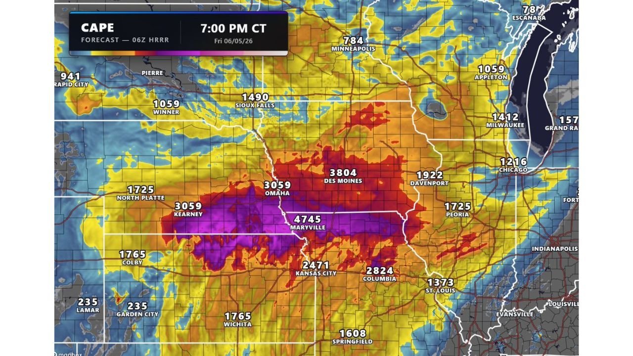
KANSAS CITY, MISSOURI — An explosive and dangerous severe weather setup is locked in for Friday June 5, 2026 across the Central Plains and Midwest, as HRRR 06Z CAPE forecast data valid at 7:00 PM CT shows extraordinary instability values peaking at 4745 J/kg near Maryville, Missouri with very large hail, significant damaging winds, and a couple of tornadoes all possible between 5:00 PM and 1:00 AM across Nebraska, Iowa, Missouri, and Kansas.
Historic Instability Values Peaked at 4745 J/kg Near Maryville and 3804 Near Des Moines
The HRRR 06Z CAPE forecast for 7:00 PM CT Friday June 5 shows some of the most extreme instability values possible across the core threat zone. Peak CAPE of 4745 J/kg near Maryville represents an extraordinary amount of storm fuel concentrated in the primary threat corridor. Additional explosive CAPE values include 3804 J/kg near Des Moines, 3059 J/kg near both Omaha and Kearney, 2471 J/kg near Kansas City, 2824 J/kg near Columbia, 1922 J/kg near Davenport, and 1725 J/kg near both Peoria and North Platte. This instability footprint stretching from Nebraska through Iowa and into Missouri creates one of the most volatile severe weather environments seen across the Central Plains in recent memory heading into Friday evening.
Nebraska, Iowa, Missouri, and Kansas Face Very Large Hail, Damaging Winds, and Tornadoes from 5PM to 1AM
The primary severe weather threat zone across Nebraska, Iowa, Missouri, and Kansas is expected to become active between 5:00 PM and 1:00 AM Friday night as a line of thunderstorms quickly develops and taps into the extreme instability field. Very large hail, significant damaging winds, and a couple of tornadoes are all explicitly anticipated hazards across this corridor during the evening window. The rapid development of a thunderstorm line in an environment with CAPE values exceeding 4000 J/kg creates a particularly dangerous setup for widespread and intense severe weather impacts across the region.
Second Threat Zone From Davenport to Milwaukee to Chicago Watching for MCV Development
A second and more conditional severe weather area is being monitored across the broader Midwest from Davenport through Milwaukee and Chicago. A Mesoscale Convective Vortex is possible if it develops from remnant storm activity earlier in the day, which could trigger a low-end tornado threat during the afternoon and early evening across this corridor. Even without MCV development, isolated damaging wind gusts will remain the primary concern across the Davenport to Chicago zone throughout Friday afternoon and evening.
Central Plains and Midwest Residents Must Be Ready Well Before 5PM Friday
With CAPE values approaching historic levels and a multi-hazard severe weather window running from 5:00 PM through 1:00 AM, residents across Nebraska, Iowa, Missouri, and Kansas must have shelter plans finalized and multiple weather alert methods activated well before Friday afternoon. This is a life-threatening severe weather setup that demands immediate preparation and awareness across the entire Central Plains and Midwest region.
Stay with GordonRamsayClub.com for the latest updates.

Leave a Reply