
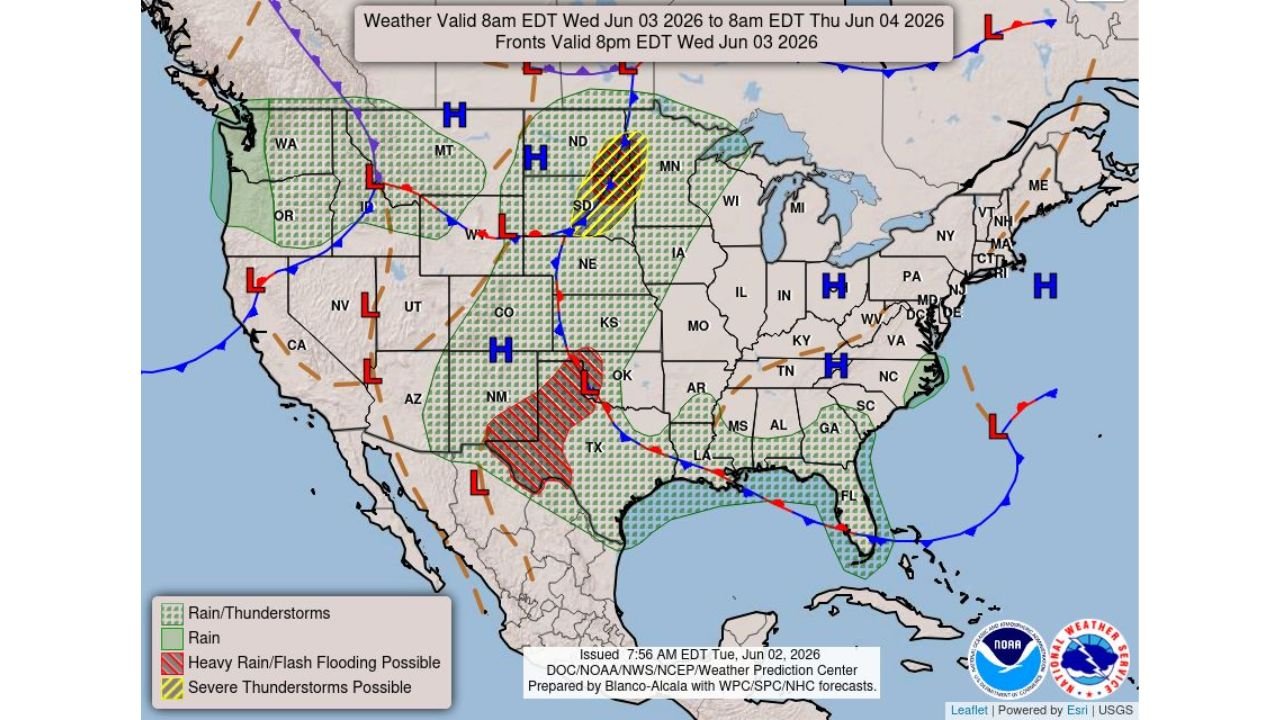
BISMARCK, NORTH DAKOTA — A dual severe weather and flash flooding threat is taking shape across the Plains for Wednesday June 3, 2026, as the NWS Weather Prediction Center outlook issued June 2, 2026 at 7:56 AM EDT and valid from 8:00 AM EDT June 3 through 8:00 AM EDT June 4 highlights severe thunderstorm potential across the northern Plains and heavy rain with flash flooding possible across the southern Plains simultaneously.
Severe Thunderstorms Possible Across Northern Plains with All Hazards on the Table
The NWS WPC outlook shows a Severe Thunderstorms Possible zone marked in yellow diagonal hatching concentrated across North Dakota and South Dakota for Wednesday June 3. Large hail, damaging winds, and possible tornadoes are all on the table across this corridor as the severe weather setup develops during the day. The threat area is focused on the eastern Dakotas region consistent with the active storm pattern that has been targeting the northern Plains repeatedly over recent days, with frontal boundaries and shortwave energy continuing to provide lift and storm initiation potential across the region.
Heavy Rain and Flash Flooding Threatening Oklahoma and Texas Wednesday
Separately, a Heavy Rain and Flash Flooding Possible zone marked in red diagonal hatching covers a significant area across Oklahoma and Texas on the WPC outlook for Wednesday. A surface low pressure center positioned over the Oklahoma and Texas border region is drawing in Gulf moisture and supporting heavy to excessive rainfall rates across this corridor. Communities across Oklahoma, north Texas, and surrounding areas should be prepared for rapidly developing flash flood conditions through the Wednesday timeframe as storm training and slow-moving convection is possible over the heavy rain zone.
Broad Rain and Thunderstorm Coverage Extends From Pacific Northwest Through Midwest and Southeast
Beyond the primary severe weather and flooding zones, the WPC outlook shows widespread rain and thunderstorm coverage extending across a large portion of the United States on Wednesday. Green dotted rain and thunderstorm hatching covers areas from Washington and Oregon through the Rockies, across the central Plains and Midwest through Iowa, Illinois, and into the Southeast through Mississippi, Alabama, Georgia, and Florida. A general rain area also covers portions of the Pacific Northwest and northern Rockies as the active multi-system pattern continues across the country.
Residents Across the Dakotas and Southern Plains Should Remain Alert All Day Wednesday
With severe thunderstorms targeting the northern Plains and flash flooding threatening Oklahoma and Texas simultaneously on Wednesday June 3, 2026, residents across North Dakota, South Dakota, Oklahoma, and north Texas should stay closely connected to local NWS forecast updates and be prepared to respond quickly to warnings and flood emergencies throughout the day.
Stay with GordonRamsayClub.com for the latest updates.

Leave a Reply