
CHICAGO, ILLINOIS — A critical long-range weather pattern signal is emerging for June 2026 as tropical forcing analogs based on MJO Phases 7 and 8 with amplitude greater than 1 heavily favor a Hudson Bay Ridge pattern that points toward drier than normal conditions across the eastern grain belt and Great Lakes while supporting a more favorable and wetter setup across the western grain belt.
MJO Phases 7 and 8 Analog Years Strongly Supporting Hudson Bay Ridge Pattern
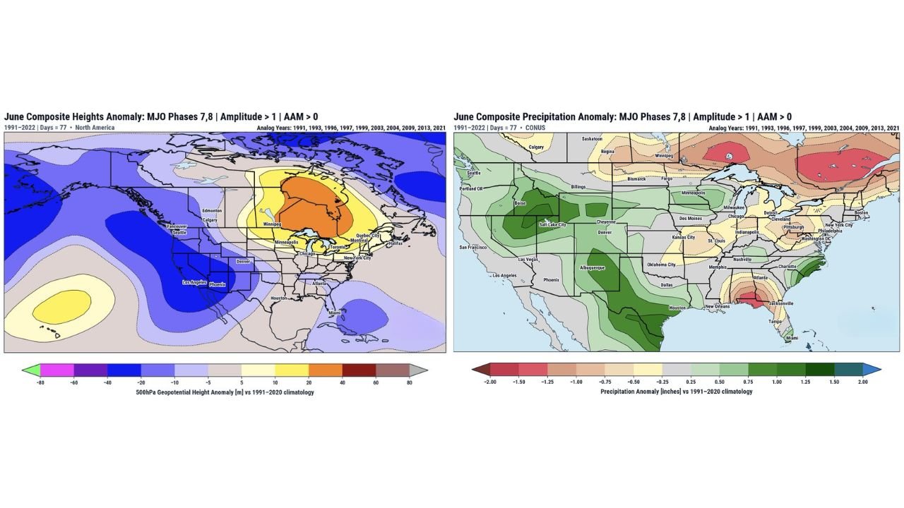
BAM Weather composite height anomaly data based on MJO Phases 7 and 8 analog years including 1991, 1993, 1996, 1997, 1999, 2003, 2004, 2009, 2013, and 2021 shows a dominant positive 500hPa geopotential height anomaly centered over Hudson Bay and extending southward into the Great Lakes, Minneapolis, Chicago, Toronto, and Montreal corridor. The deep orange and red anomaly values over Hudson Bay and eastern Canada indicate a strongly amplified ridge in this region, which historically has significant downstream implications for precipitation distribution across the continental United States during June.
Eastern Grain Belt Leaning Drier as Western Grain Belt Sees More Favorable Setup
The June composite precipitation anomaly map based on the same MJO Phase 7 and 8 analogs shows a clear and concerning precipitation signal for the eastern grain belt. The Great Lakes corridor including Chicago, Detroit, Cleveland, Indianapolis, and Pittsburgh trends toward below normal to near normal precipitation during this pattern. Meanwhile the western grain belt covering areas near Boise, Salt Lake City, Denver, and Cheyenne trends notably wetter and more favorable, with above normal precipitation anomalies clearly visible across the Intermountain West and northern Rockies. Texas, the Gulf Coast near Houston, and Florida near Jacksonville and Tampa also show above normal precipitation signals under this pattern.
Pattern Verification Over Next 6 to 10 Days Absolutely Critical to Watch
Forecasters are emphasizing that while the tropical forcing analogs heavily favor the Hudson Bay Ridge signal, the pattern verification over the coming 6 to 10 days will be absolutely critical to monitor closely. The current global wind pattern and a stronger Pacific jet stream represent potential modifying factors that could alter how closely the forecast follows the analog signal. Any deviation in rain forecast outcomes versus model projections during this window could have significant implications for crop development across the eastern grain belt heading deeper into June 2026.
Agricultural Interests Across Eastern Corn Belt Should Monitor Closely This Week
With MJO analog composites leaning drier for the eastern grain belt and the broader Hudson Bay Ridge signal gaining support from tropical forcing patterns, agricultural interests across Illinois, Indiana, Ohio, and surrounding eastern corn and soybean belt states face a potentially critical period ahead. Staying closely connected to updated long-range forecast discussions over the next several days is strongly recommended.
Stay with GordonRamsayClub.com for the latest updates.

Leave a Reply