
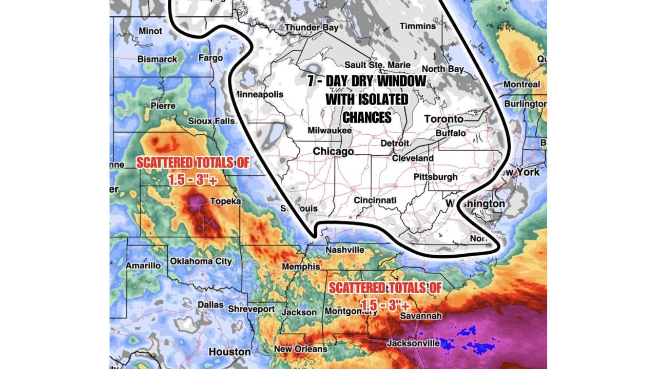
CHICAGO, ILLINOIS — A stark and well-defined precipitation divide is setting up across the United States over the next seven days, with BAM Weather’s modeled rainfall totals through June 4 showing a broad dry window locked in across the Ohio Valley and Great Lakes region while scattered totals of 1.5 to 3 inches or more are projected across the central and southeastern United States during the same period.
7 Day Dry Window With Isolated Chances Covers Chicago, Cleveland, Detroit and the Great Lakes
The BAM Weather Week Long Dry Window graphic shows a large outlined zone encompassing the entire Great Lakes region and Ohio Valley corridor within a 7-Day Dry Window With Isolated Chances designation. This dry zone covers Minneapolis, Milwaukee, Chicago, Detroit, Cleveland, Cincinnati, Pittsburgh, Buffalo, Toronto, and Washington DC, placing a massive swath of the upper Midwest and mid-Atlantic within the predominantly dry forecast through June 4.
The gray and white shading inside this outlined zone on the modeled rainfall map confirms minimal precipitation accumulation expected across the region over the coming week. While isolated rain chances cannot be completely eliminated, the overall pattern strongly favors a dry stretch for tens of millions of residents across the Ohio Valley and Great Lakes states through the end of the forecast period.
Scattered 1.5 to 3 Inch Totals Expected Across the Southeast From Nashville to Savannah
South of the dry zone boundary, the forecast picture changes dramatically. Scattered rainfall totals of 1.5 to 3 inches or more are projected across the southeastern United States through June 4, covering Nashville, Memphis, Jackson, Montgomery, Savannah, Jacksonville, and New Orleans. The warm orange, red, and purple shading on the modeled rainfall map south and east of the dry zone boundary reflects the continued active and moisture-rich pattern that has dominated the Southeast in recent weeks.
This ongoing wet signal across the Southeast aligns with the broader subtropical jet stream moisture feed that has been keeping the region in an unsettled pattern, and the BAM Weather forecast suggests that pattern will persist without meaningful interruption through at least June 4.
Central Plains Seeing Scattered 1.5 to 3 Inch Totals Around Topeka and Oklahoma City
On the western side of the map, another zone of scattered 1.5 to 3 inch or more rainfall totals is projected across the central plains, with deep red and purple shading concentrated near Topeka, Kansas and extending into Oklahoma, reflecting active convective rainfall potential across that corridor over the next seven days. Oklahoma City, Dallas, and Shreveport also sit within the wetter portion of the national rainfall forecast through June 4.
Residents across the Ohio Valley and Great Lakes should enjoy the upcoming dry stretch while those across the South and central plains should continue monitoring flood and heavy rain potential through the week.
Stay with GordonRamsayClub.com for the latest updates.

Leave a Reply