
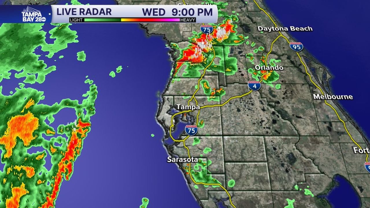
TAMPA, FLORIDA — A significant shift in Florida’s daily storm timing is underway, with Gulf moisture visible on radar set to arrive along the west coast of Florida on Thursday morning and flip the typical late afternoon and evening storm pattern to a morning showers and storms setup for the Tampa Bay region and surrounding central Florida communities.
Heavy Rain Band Clearly Visible in the Gulf Moving Toward Tampa Bay Coast at 9 PM Wednesday
Tampa Bay 28 Live Radar captured at 9:00 PM Wednesday May 27, 2026 shows a substantial and active band of rainfall positioned in the Gulf of Mexico to the west of the Florida coastline, with orange and red radar returns indicating moderate to heavy rainfall rates within the approaching moisture band. The green precipitation shading extends broadly across the Gulf surface, confirming a large and organized area of rainfall is tracking eastward toward the Tampa Bay coastline.
This Gulf moisture band is expected to reach the west central Florida coast by Thursday morning, delivering the first round of showers and storms to the Tampa, Sarasota, and surrounding areas during the early morning hours rather than the typical afternoon convective window that has characterized the recent Florida weather pattern.
Active Storm Cell Already Firing Over Central Florida Near Orlando and Daytona Corridor
The 9:00 PM Wednesday radar also shows an intense storm cell already active over central Florida, with white and red radar cores indicating very heavy rainfall concentrated near the I-75 corridor north of Tampa and extending toward the Orlando and Daytona Beach region along the I-4 and I-95 corridors. This overnight activity reflects the increasingly active and moisture-rich environment now enveloping the Florida peninsula as Gulf moisture surges into the region.
Scattered green returns are visible across multiple other portions of central and southern Florida on the radar snapshot, indicating widespread shower and storm activity is already ongoing across the state well into the Wednesday evening hours.
Late Day Storm Pattern Shifting to Morning Setup as Gulf Moisture Increases
Forecasters are noting that the typical late day storm pattern that Florida residents have become accustomed to during recent weeks is about to undergo a meaningful shift. As the Gulf moisture band moves onshore Thursday morning, the primary window for showers and storms will migrate to the morning hours rather than the afternoon and evening, catching residents off guard if they are not aware of the changed timing.
Tampa Bay area residents should prepare for morning storms on Thursday and monitor updated radar and forecasts before heading out for the day.
Stay with GordonRamsayClub.com for the latest updates.

Leave a Reply