
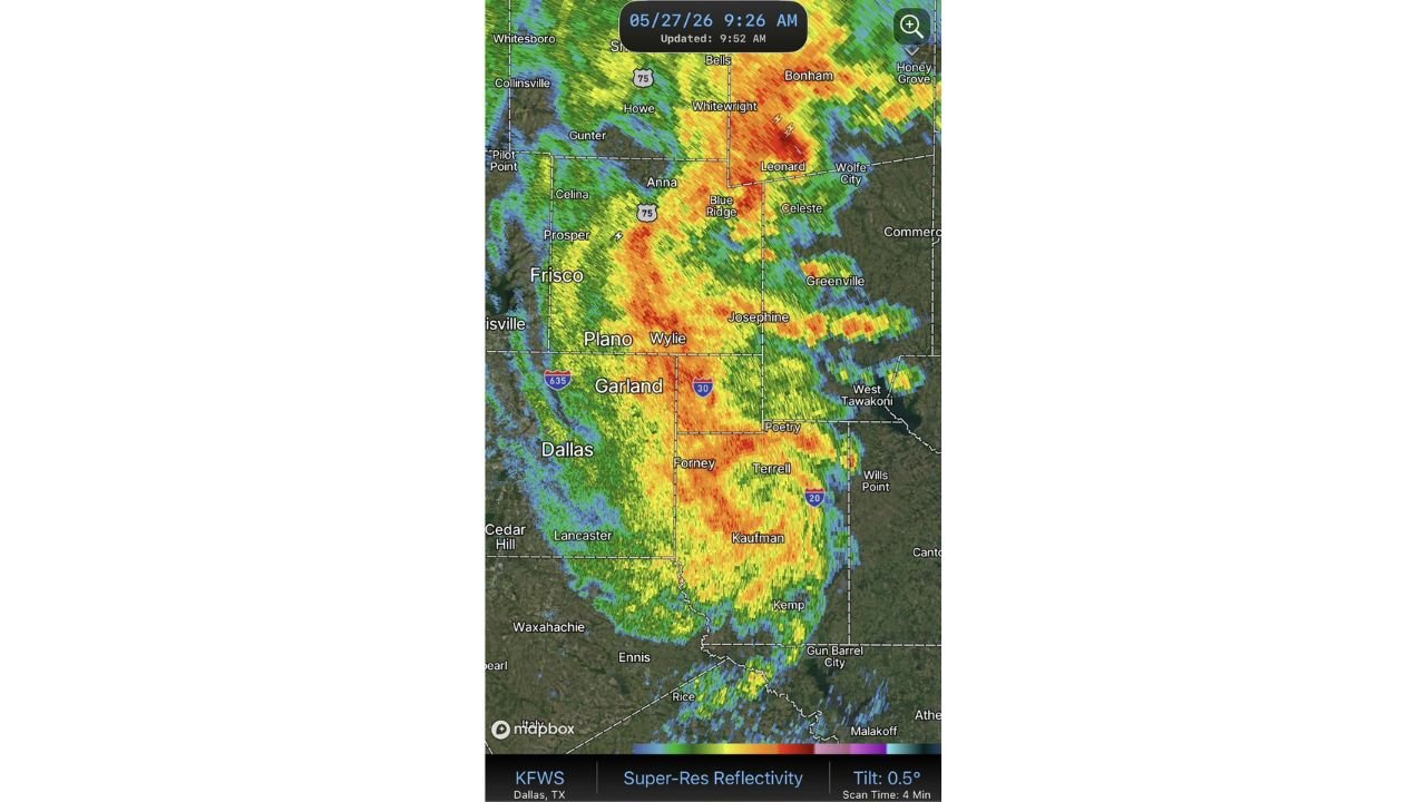
DALLAS, TEXAS — A remarkably well-organized Mesoscale Convective Vortex is sweeping through the Dallas metro and surrounding north Texas communities this Wednesday morning May 27, 2026, with KFWS Dallas Super-Resolution Reflectivity radar captured at 9:26 AM showing a tightly structured and intense storm system tracking through Garland, Plano, Frisco, and extending northeast toward Leonard, Greenville, and Bonham.
MCV Radar Presentation Described as More Organized Than Most Atlantic Hurricane Season Systems
The level of organization displayed by this MCV on radar is drawing significant attention, with meteorologists noting that this system is more organized than almost anything the Atlantic basin will produce during the entire 2026 hurricane season. The tight rotational structure, clearly defined core, and coherent spiral banding visible on the KFWS Super-Res radar at 0.5 degree tilt are hallmarks of a well-developed mesoscale circulation that is rare to see in a purely continental convective setup.
This level of radar-indicated organization makes the system capable of producing concentrated and intense weather impacts across whatever communities fall within its direct path as it tracks through north Texas this morning.
Intense Red and Orange Radar Core Centered Over Garland, Wylie and Forney
The KFWS radar imagery shows the most intense reflectivity values concentrated in a deep red and orange core positioned over Garland, Wylie, and Forney at the time of the 9:26 AM scan. These high reflectivity returns indicate heavy rainfall rates and potentially embedded stronger convective elements within the MCV circulation as it pushes through the eastern Dallas metro corridor.
Plano, Prosper, Anna, Blue Ridge, Celeste, Josephine, Terrell, and Kaufman are all sitting within or immediately adjacent to the intense radar returns, keeping a broad swath of Collin, Rockwall, and Kaufman counties within the heaviest precipitation footprint of the morning storm system.
Storm Tracking Northeast From Dallas Metro Toward Greenville and Bonham
The overall track of the MCV is carrying it in a northeastward direction away from the core Dallas metro and toward Greenville, Bonham, Leonard, and Wolfe City as the system continues its progression across north Texas. Communities along this northeast corridor should prepare for the arrival of heavy rain and potentially gusty conditions as the organized circulation moves through the region through the mid-morning hours.
Stay with GordonRamsayClub.com for the latest updates.

Leave a Reply