
NEW ORLEANS, LOUISIANA — Tropical moisture is set to surge northward from the Caribbean into the southern and eastern United States over the next week, with NOAA forecasts showing widespread heavy rain developing across the South and Southeast as the pattern amplifies through the end of May and into June.
NOAA 168 Hour QPF Shows Heavy Rain Footprint Across Gulf Coast and Southeast Through June 1
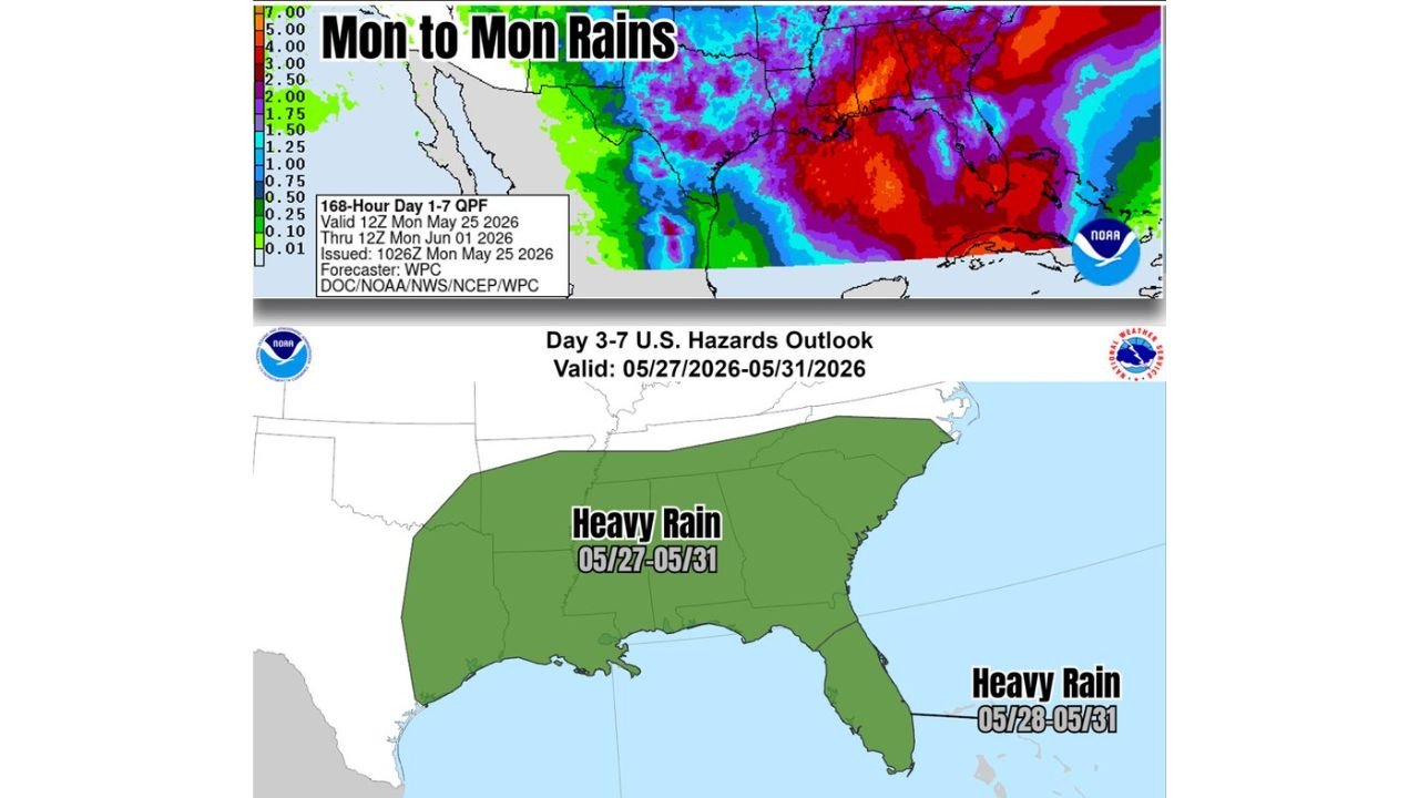
The NOAA Weather Prediction Center 168-Hour Day 1 through 7 Quantitative Precipitation Forecast, valid from 12Z Monday May 25, 2026 through 12Z Monday June 1, 2026, shows a broad and intense rainfall footprint across the Gulf Coast, Deep South, and Southeast. Deep red and purple shading on the map indicates the highest projected totals are concentrated across Louisiana, Mississippi, Alabama, Tennessee, and into the Carolinas.
The combined 7-day totals across this corridor are significant, though forecasters note the rainfall will not be a complete washout for all areas. The distribution is expected to be spotty in nature, meaning where, when, and how much rain falls will vary considerably from location to location across the broader impacted region.
Day 3 to 7 Hazards Outlook Flags Heavy Rain Risk Across Entire South From May 27 to May 31
The NWS Day 3 to 7 U.S. Hazards Outlook, valid May 27 through May 31, 2026, has issued a Heavy Rain designation covering the entire southern United States in a broad green shading zone. This hazard zone stretches from Texas and Oklahoma eastward through Louisiana, Mississippi, Alabama, Georgia, Tennessee, and the Carolinas.
A secondary Heavy Rain designation valid specifically from May 28 through May 31 is also highlighted across Florida and the surrounding coastal zone, indicating the tropical moisture surge will have a particularly pronounced impact across the peninsula during the latter half of the outlook period.
Rain Chances Up Across the Region but Spotty Distribution Expected
Forecasters are clear that while rain chances are elevated significantly across the South and East due to the Caribbean tropical moisture flow, the overall pattern will not produce uniform flooding rainfall everywhere. Some areas will see much higher totals than others depending on where individual storm clusters set up each day.
Residents across the entire South should anticipate an unsettled and wet weather pattern through May 31 and monitor local forecasts closely as the tropical moisture moves in.
Stay with GordonRamsayClub.com for the latest updates.

Leave a Reply