
CENTRAL AND EASTERN NORTH CAROLINA — Scattered showers and thunderstorms are moving through central and eastern sections of North Carolina this Saturday morning as of 8:52 AM, with passing showers expected to continue across the region throughout the morning hours. A particularly concerning development is a strong storm cell being monitored off Ocracoke Island that could produce waterspouts, adding a marine weather hazard to the broader shower and storm activity impacting the state this morning.
What the Radar Shows at 8:52 AM
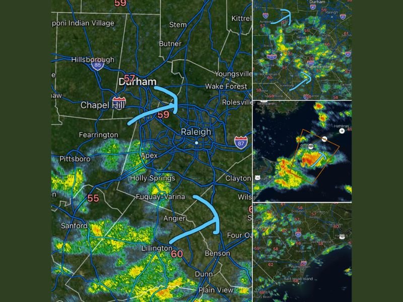
Radar at 8:52 AM Saturday shows scattered green returns pushing through the Raleigh, Durham, and Chapel Hill triangle area, with additional shower activity visible across the broader central North Carolina corridor including Wake Forest, Rolesville, Apex, Holly Springs, Fuquay-Varina, and Lillington. Temperatures across the region are running in the upper 50s to low 60s, with Durham at 57 degrees, Raleigh and Chapel Hill at 59 degrees, and Lillington at 60 degrees.
Eastern North Carolina is also seeing scattered shower activity across communities including Fayetteville, Goldsboro, Dunn, and surrounding areas, with the storm activity tracking through the region during the morning hours.
Strong Storm Off Ocracoke Monitoring for Waterspouts
The most significant weather concern as of Saturday morning is a strong storm cell being actively monitored off Ocracoke Island along the North Carolina Outer Banks. The cell, visible on radar with intense red and orange returns positioned offshore, is being tracked for waterspout development given the atmospheric conditions present in that coastal zone this morning.
A warning box has been outlined on radar around the Ocracoke area storm, indicating that meteorologists are treating this offshore cell as a serious waterspout threat for the waters surrounding the Outer Banks. Mariners and coastal residents near Ocracoke, Hatteras, and surrounding Outer Banks communities should remain on high alert for any waterspout activity developing from this offshore storm cell.
What to Expect for the Rest of the Morning
Passing showers will continue moving through central and eastern North Carolina throughout the morning hours following the 8:52 AM radar snapshot. The scattered and hit or miss nature of the shower activity means some communities will see brief periods of heavier rain while others experience lighter activity or miss the showers entirely as the system tracks through the region.
Residents across the Raleigh, Durham, Fayetteville, and broader central and eastern North Carolina areas should keep umbrellas handy and be aware of wet road conditions during the morning commute as scattered showers continue pushing through the region. Stay with GordonRamsayClub.com for the latest updates.

Leave a Reply