
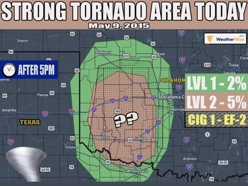
WESTERN OKLAHOMA — A strong tornado potential exists across portions of western Oklahoma today, May 9, 2026, if supercells manage to develop despite significant atmospheric uncertainty surrounding storm initiation. Shear profiles strongly favor southeast moving supercells capable of producing strong tornadoes up to EF-2 intensity across the outlined risk zone covering Altus, Lawton, Woodward, and surrounding western Oklahoma communities after 5 PM. However, a strengthening cap and limited moisture return could prevent storms from forming entirely, making this one of the more uncertain severe weather setups of the season.
Why This Setup Is So Uncertain
Short term forecast models are struggling significantly with today’s western Oklahoma severe weather potential, with some guidance keeping the entire area completely devoid of storm activity throughout the day while others show discrete supercell development occurring across the region. The strengthening atmospheric cap, which acts as a lid suppressing storm development, is a major factor creating this uncertainty.
Moisture return into the region could also be limited throughout the day, further reducing the chances of storm initiation across western Oklahoma during the afternoon hours. Given these limiting factors, meteorologists believe storms are most likely to hold off until the evening hours after 5 PM when moisture should begin flowing northward more rapidly.
What Happens If Supercells Do Develop
If discrete supercells do manage to break through the cap and develop across western Oklahoma this evening, the atmospheric setup strongly favors dangerous storm activity. Shear profiles are highly supportive of southeast moving supercells, and any sustained storm that develops and taps into the northward flowing moisture as the low level jet ramps up during the evening hours could become significantly tornado-capable.
The risk zone carries a Level 2 five percent tornado probability across the core area covering Altus and Lawton, with a broader Level 1 two percent probability zone extending outward through Woodward and toward the Oklahoma City metro on the eastern edge. Any tornadoes that develop with supercells tonight could reach EF-2 intensity under the right conditions.
Timing After 5 PM
Storm development, if it occurs at all today, is most likely to begin after 5 PM across western Oklahoma as evening conditions become more favorable for supercell initiation. The evening hours will see moisture flowing northward more rapidly and the low level jet strengthening, both of which could provide the boost needed for any storms that manage to develop through the cap.
Residents across Altus, Lawton, Woodward, and surrounding western Oklahoma communities should remain weather aware from 5 PM onwards and monitor updated forecasts throughout the afternoon as the situation evolves. Stay with GordonRamsayClub.com for the latest updates.

Leave a Reply