
ALABAMA — A band of showers and thunderstorms is draped across the US-80 corridor in South Alabama this morning, with heavy rain falling from Selma to Montgomery where over 5 inches of rain was already measured earlier this week. The northern half of Alabama remains rain-free while periods of rain will continue across South Alabama throughout today with high temperatures expected between 75 and 82 degrees statewide.
Current Radar Situation This Morning
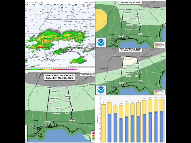
Heavy rain is actively falling across the US-80 corridor from Selma through Montgomery in South Alabama as of Saturday morning, with radar showing intense green and yellow returns concentrated across that southern corridor. The northern half of the state including Florence, Huntsville, Birmingham, and Tuscaloosa remains generally dry and rain-free this morning as the storm activity stays confined to the southern portions of the state.
Montgomery has already seen significant rainfall accumulation this week, with over 5 inches recorded at that location prior to today’s additional rainfall, raising concerns about saturated ground and the potential for localized flooding as more rain continues to fall across the region.
Rest of Saturday and Sunday Outlook
Periods of rain will continue across South Alabama throughout today while North Alabama stays generally dry with only a few small isolated showers possible around this evening. High temperatures on Saturday will range between 75 and 82 degrees across the state.
Sunday, May 10, brings a mostly dry day with temperatures climbing into the low 80s across Alabama. However, scattered showers and storms are expected to develop late Sunday afternoon and into Sunday night ahead of an approaching cold front. The SPC has outlined a Marginal Risk of severe storms for the southern half of Alabama on Sunday, with a few thunderstorms capable of producing gusty winds and hail. Importantly, there is no tornado risk associated with Sunday’s storm system.
Monday Brings End to Rain and Warming Trend Begins
Showers and storms associated with the cold front will end Monday morning as dry air rolls into Alabama during the afternoon hours. The rest of the week following Monday looks dry across the state with a significant warming trend developing through the week.
Long range guidance suggests temperatures across Alabama will reach the low 90s by May 17 through 20 as an upper level ridge builds across the region, bringing the first genuine summer-like heat of the season to communities statewide.
What Residents Should Know
South Alabama residents should expect continued rainy conditions through today with the heaviest activity remaining along and south of the US-80 corridor. Those with outdoor Mother’s Day plans on Sunday should be aware of the late afternoon and evening storm risk for the southern half of the state before conditions improve Monday afternoon. Stay with GordonRamsayClub.com for the latest updates.

Leave a Reply