
ARKANSAS — A warm and pleasant Saturday is unfolding across Arkansas with high temperatures climbing into the low to mid 80s statewide and light winds making for comfortable afternoon conditions across the Natural State. However, meteorologists are watching the potential for storms to develop late tonight, possibly in the middle of the night, mainly across the western half of Arkansas with a limited severe weather risk possible alongside that activity.
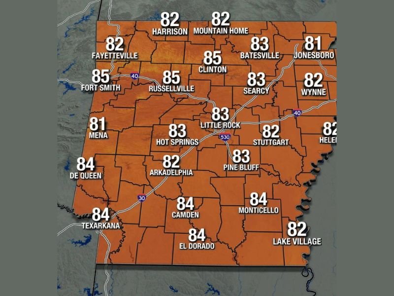
Saturday High Temperatures Across Arkansas
The Arkansas Weather Network Saturday high temperature map shows a statewide warmup with temperatures ranging from the low 80s in northern and eastern communities up to the mid 80s across central and western portions of the state.
Northern Arkansas communities including Harrison, Mountain Home, and Fayetteville will reach highs of 82 degrees, while Jonesboro on the eastern side of the state also tops out at 81 degrees. Central Arkansas sees temperatures climbing higher, with Clinton and Russellville both hitting 85 degrees, Little Rock reaching 83, and Searcy coming in at 83 degrees as well. Fort Smith in western Arkansas also reaches 85 degrees on Saturday afternoon.
Southern Arkansas will be among the warmer areas of the state with De Queen at 84, Camden at 84, El Dorado at 84, Monticello at 84, and Texarkana also hitting 84 degrees. Hot Springs reaches 83 and Pine Bluff climbs to 83 degrees across the south central corridor.
Late Night Storm Potential for Western Arkansas
While Saturday afternoon looks warm and pleasant across the state, meteorologists are monitoring the potential for storms to develop late tonight, possibly during the middle of the night hours, mainly across the western half of Arkansas. A limited severe weather risk is possible alongside any storms that develop during this overnight window.
Further data and model guidance will be analyzed throughout the morning and a mid to late morning update is expected from the Arkansas Weather Network with more details on the overnight storm potential and any associated severe weather risk heading into Saturday night.
Mother’s Day Forecast Coming
Updated Mother’s Day forecast information for Sunday is also expected from the Arkansas Weather Network alongside the mid morning storm update, giving Arkansas residents a clearer picture of what conditions to expect for the holiday weekend as the week progresses.
Residents across western Arkansas in particular should monitor updated forecasts throughout the day Saturday as the overnight storm potential comes into sharper focus ahead of any late night activity. Stay with GordonRamsayClub.com for the latest updates.

Leave a Reply