
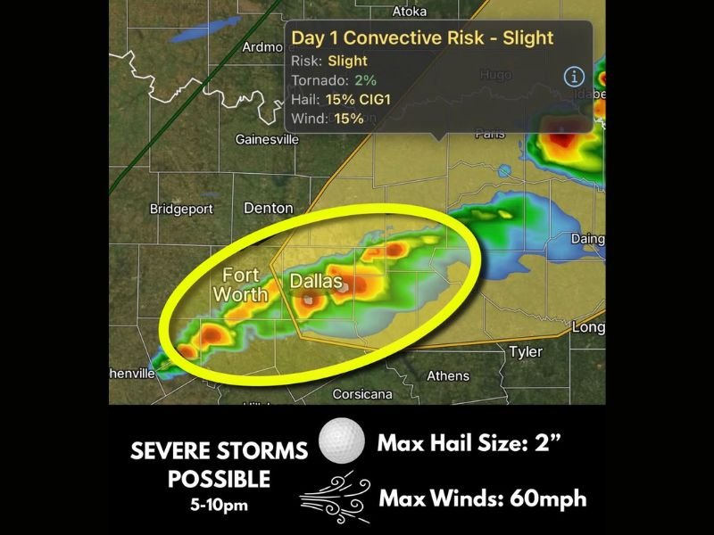
DALLAS FORT WORTH, TEXAS — Severe weather is possible across the Dallas Fort Worth Metroplex today, with the strongest storms capable of producing quarter to golf ball sized hail up to 2 inches in diameter and damaging winds reaching up to 60 mph. The threat window to watch is 5 PM to 10 PM, with a Slight convective risk in place carrying a 2% tornado probability, 15% hail risk, and 15% damaging wind risk across the highlighted zone covering Fort Worth and Dallas.
What Threats Are Expected Today
The strongest storms moving through the Metroplex between 5 PM and 10 PM tonight could produce hail ranging from quarter size up to golf ball size, with a maximum hail size of 2 inches confirmed in the outlook. Damaging winds up to 60 mph accompany the hail threat as the primary hazards for the Dallas Fort Worth area during tonight’s severe weather window.
Storm coverage is not expected to be widespread, and some storms may struggle to fully organize. However, any storm that does reach severe criteria has the potential to produce significant hail and damaging winds across the Fort Worth and Dallas corridor.
Tornado Threat Exists But Remains Low
A tornado threat exists across the Metroplex today but remains low and conditional. The Day 1 Convective outlook places a 2% tornado probability across the area, meaning isolated tornadoes cannot be fully ruled out but are not the primary concern with today’s storm system.
Higher tornado chances exist further northeast toward Texarkana, where atmospheric conditions are more favorable for tornado development compared to the core Dallas Fort Worth zone.
Slight Risk Details for the Metroplex
The Day 1 Convective Risk for the Dallas Fort Worth Metroplex is classified as Slight, carrying specific probabilities of 2% for tornadoes, 15% for hail, and 15% for damaging winds. The highlighted zone on today’s storm map circles directly over Fort Worth and Dallas, confirming these two major urban centers as the primary focus of tonight’s severe weather concern between 5 PM and 10 PM.
What Residents Should Do
Metroplex residents are urged to stay weather aware from 5 PM onwards this evening. Monitor local weather alerts closely and be prepared to take shelter quickly if a severe thunderstorm warning is issued for your specific county during tonight’s active weather window. Stay with GordonRamsayClub.com for the latest updates.

Leave a Reply