
SOUTH CENTRAL UNITED STATES — A large Slight Risk of severe weather has been placed in effect for Wednesday, May 6, 2026, covering a wide stretch of the South Central United States including Houston, Shreveport, Jackson, and Birmingham. The outlook, updated by Max Velocity Weather on May 3, 2026 at 4:02 AM ET, carries the potential for significant severe weather with multiple tornadoes and destructive straight line winds both on the table depending on how storm mode develops over the coming days.
What Threats Are Possible Wednesday
Meteorologists have identified two possible scenarios for Wednesday’s storm activity, both carrying serious severe weather potential. If discrete supercells manage to form, multiple tornadoes could become possible across the threat zone, representing the higher-end outcome for the event.
The more likely scenario at this stage is that storms cluster together, producing a more organized line with a significant straight line wind threat and embedded tornadoes rather than isolated supercell activity. Either outcome carries destructive potential for communities across the affected region.
Areas Inside the Risk Zone
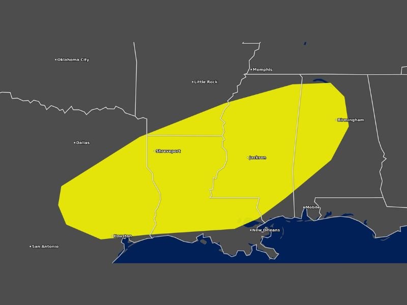
The 15% severe weather risk zone covers a large oval-shaped corridor stretching from the Houston area in the southwest through Shreveport, Jackson, and extending northeast toward Birmingham and Mobile. Little Rock and New Orleans also sit near the edges of the outlined threat area on the Max Velocity Weather severe outlook map.
The sprawling nature of the risk zone means millions of residents across Louisiana, Mississippi, Alabama, and parts of Texas are within the potential impact area for Wednesday’s storm system.
High Uncertainty Remains
Meteorologists were upfront about the significant amount of uncertainty still surrounding storm mode for this event. Whether storms organize into discrete supercells or cluster into a squall line will determine the exact nature and distribution of the severe weather threat across the region.
Further forecast updates are expected over the coming days as the storm system comes into sharper focus and confidence in storm mode increases among weather modeling data.
What Residents Should Do Now
With Wednesday’s threat still several days out, residents across Houston, Shreveport, Jackson, Birmingham, and surrounding communities have time to prepare. Monitor updated forecasts daily as details become clearer, ensure your severe weather plan is in place, and keep weather alert notifications active on all devices heading into midweek. Stay with GordonRamsayClub.com for the latest updates.

Leave a Reply