
NORTHERN ILLINOIS — Scattered strong thunderstorms carrying damaging wind and hail are forecast to impact northern Illinois during the late afternoon and evening hours on Monday, May 4, 2026. The National Weather Service Storm Prediction Center issued a severe weather outlook valid through May 5, 2026 at 7:00 AM CDT, with the threat developing along and ahead of an advancing cold front pushing through the region.
Which Areas Are Under Threat Monday
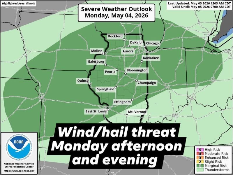
The severe weather outlook covers a wide stretch of northern and central Illinois, placing numerous major cities within the threat zone. Areas including Chicago, Rockford, DeKalb, Aurora, Moline, Galesburg, Peoria, Bloomington, Champaign, Kankakee, Quincy, Springfield, Effingham, East St. Louis, and Mt. Vernon all fall within the outlined risk area on the NOAA Storm Prediction Center map.
The bulk of the threat is concentrated across the northern half of the state where storm coverage is expected to be highest during the late afternoon and early evening window.
What Hazards Are Expected
The two primary hazards associated with Monday’s storm threat are damaging winds and hail. Thunderstorms developing along and ahead of the cold front will carry enough energy to produce wind gusts capable of causing damage, along with hail that could impact vehicles, crops, and property across the affected counties.
The outlook was last updated on May 3, 2026 at 12:03 AM CDT, reflecting the latest available data from NOAA meteorologists tracking the approaching front and its severe weather potential across Illinois.
Timing of the Threat
Storm activity is expected to ramp up during the late afternoon hours on Monday and continue through the evening as the cold front progresses eastward across the state. Residents across northern and central Illinois should be weather aware throughout the entire afternoon and evening period rather than waiting for storms to arrive before taking precautions.
What Residents Should Do
All residents within the outlined threat zone are urged to monitor local weather alerts closely throughout Monday. Keep a weather app or NOAA Weather Radio accessible, and have a shelter plan ready in case a severe thunderstorm warning is issued for your specific county. Secure any outdoor furniture or loose objects that could become hazardous in damaging wind conditions before storm activity arrives Monday afternoon. Stay with GordonRamsayClub.com for the latest updates.

Leave a Reply