
McLENNAN COUNTY / WACO, TEXAS — A Severe Thunderstorm Warned storm packed with a massive hail core was moving southeast into McLennan County at 10:15 p.m. Tuesday, with golf ball-size hail already confirmed on the ground in Gholson — as forecasters urgently warned the north side of Waco including Bellmead, Elm Mott, and Lacy-Lakeview to immediately prepare for incoming large hail.
Golf Ball Hail Confirmed on Ground in Gholson
Ground reports confirmed golf ball-size hail — approximately 1.75 inches in diameter — striking Gholson, Texas as the Severe Thunderstorm Warned storm moved through the area at 10:08 p.m. Tuesday. Golf ball-size hail is well above the severe hail threshold and is capable of causing serious damage to vehicles, rooftops, and any exposed property or individuals caught outdoors.
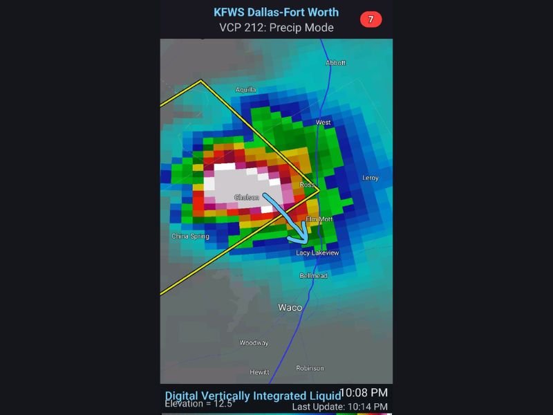
Radar at 10:08 p.m. clearly showed the massive white hail core signature centered directly over the Gholson area — the white and grey coloring on the Digital Vertically Integrated Liquid radar scan indicating the most extreme precipitation intensity at the heart of the warned storm cell.
Severe Thunderstorm Warning Storm Tracking Southeast Into McLennan County
The Severe Thunderstorm Warning box was clearly outlined on radar at the time of the 10:15 p.m. update, with the storm tracking on a southeast path directly into McLennan County. The storm’s motion arrow pointed squarely toward Elm Mott and Lacy-Lakeview — placing those communities immediately north of Waco directly in the path of the hail core within minutes of the update.
The broader storm cell encompassed a wide area including Aquilla, West, Ross, China Spring, and surrounding communities all within the warned zone as the system continued its southeast march.
Bellmead Elm Mott and Lacy-Lakeview Urged to Prepare Immediately
Forecasters issued an urgent and specific call to action for three communities on the north side of Waco — Bellmead, Elm Mott, and Lacy-Lakeview — to prepare for hail immediately as the storm’s hail core bore down on their locations.
All three communities sit directly in the southeast storm track path shown on radar, placing them at imminent risk of experiencing the same golf ball-size or larger hail that had already struck Gholson moments earlier.
Waco Proper South of Immediate Hail Core Path
While the immediate hail threat at 10:15 p.m. was most concentrated on Waco’s north side communities, the broader Waco metro area including Woodway, Hewitt, and Robinson to the south remained within the general warned storm zone and could experience hail and severe thunderstorm impacts as the system continued tracking southeast through McLennan County through the late evening hours.
Residents across the entire north Waco corridor were urged to bring vehicles under cover immediately, stay indoors, and away from windows until the warned storm passed their location. Stay with GordonRamsayClub.com for the latest updates.

Leave a Reply