
ALABAMA — A band of light rain was continuing to drop southward across Central and South Alabama early Sunday morning, though forecasters indicated the rain would fade over the next few hours as skies became sunny. Today will be noticeably cooler with highs ranging from 66 to 74 degrees for most communities, before a strong warming trend pushes afternoon highs back into the 80s by Tuesday and holds through much of the week ahead.
Light Rain Band Fading Across Central and South Alabama This Morning
Radar showed a band of light rain moving southward across Central and South Alabama during the early morning hours of April 19, 2026. The rain was not expected to be a persistent or impactful feature of the day, with forecasters indicating the precipitation would fade within the next few hours as clearing skies and sunny conditions gradually developed across the state through the morning.
The radar composite showed the rain band concentrated across the central and southern portions of Alabama, with the activity continuing to push southward and diminish as the morning progressed.
Much Cooler Today With Highs of 66 to 74 — Temperatures Drop to the 40s Monday Morning
Sunday will feel noticeably cooler across Alabama compared to recent days, with afternoon highs expected to land in the 66 to 74 degree range for most communities statewide. The cooler conditions will extend into Monday morning, with temperatures dropping into the 40s across much of the state during the overnight and early morning hours before the warming trend takes hold through the week.
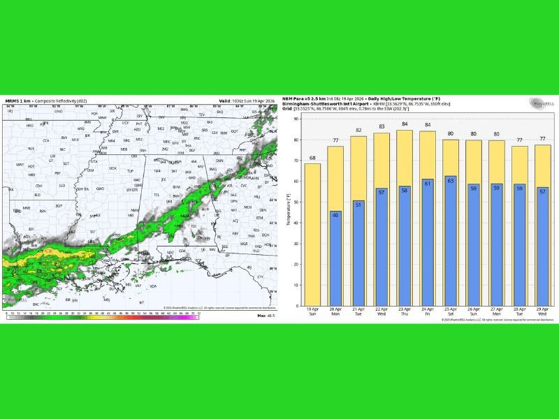
The temperature forecast chart confirmed Sunday’s high near 68 degrees at Birmingham-Shuttlesworth International Airport, marking the coolest day in the week ahead outlook.
Warming Trend Returns 80s by Tuesday — Unsettled Weekend Ahead With 1 to 2 Inches of Rain Possible
The week ahead outlook showed a strong and steady warming trend developing from Monday onward, with afternoon highs returning to the low 80s by Tuesday and holding in the 82 to 84 degree range through Thursday and Friday. Mostly sunny days and clear nights were expected through the mid-week period.
However the upcoming weekend brought renewed weather concerns, with a chance of showers developing Friday over the western half of the state and unsettled conditions with occasional showers and thunderstorms expected both Saturday and Sunday. Most of Alabama carries the potential for 1 to 2 inches of rain over the weekend, with the severe thunderstorm threat still too early to determine at this time. Stay with GordonRamsayClub.com for the latest weather updates and detailed forecast coverage.

Leave a Reply