
LAFAYETTE, INDIANA — The line of storms pushing through central Indiana was beginning to show significant signs of weakening, with the system leaking through the region and sporting an outflow boundary circled out ahead of the main line — a strong indicator of a dying system. However, forecasters warned that while the main line was weakening, the outflow boundary remained capable of triggering new cells out ahead of the system. Up north, pockets of rotation, severe level winds, and hail were still showing signs of life near the Crown Point and Plymouth corridor.
Storm Line Leaking Through Central Indiana — Outflow Boundary Developing Ahead of Main Line
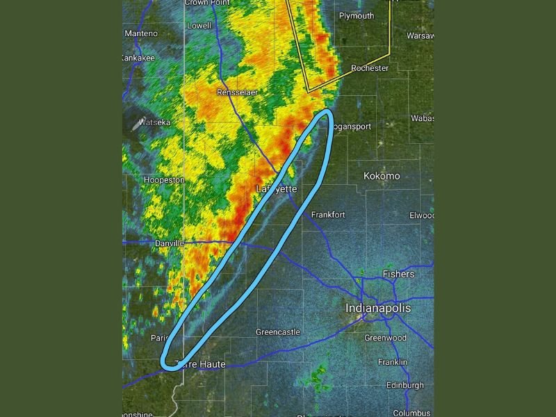
Radar showed the main storm line pushing through central Indiana from Crown Point and Lowell in the north through Rensselaer, Lafayette, Danville, and down toward Terre Haute in the south. A prominent outflow boundary, highlighted in blue on radar, was visible curving out ahead of the main line from the Logansport area southward through Lafayette and down to Terre Haute, signaling the system was losing its organizational structure.
Forecasters noted the outflow boundary was a clear indicator of a weakening and dying system, but emphasized that such boundaries are capable of triggering new storm development out ahead of the main line, making continued weather awareness necessary across the region.
Rotation, Severe Winds and Hail Still Ongoing in Northern Indiana
Despite the overall weakening trend, the northern end of the storm line near Crown Point, Plymouth, and Westville continued to show active and concerning radar signatures. A warned box was visible on radar in the northern zone near Westville, with pockets of rotation and severe level winds and hail still being detected in that corridor.
The northern portion of the line maintained intense yellow, orange, and red radar returns, indicating heavier rainfall cores and embedded stronger cells continuing to pose a threat to communities in that zone including Nappanee, Warsaw, and the surrounding areas.
Outflow Boundary Could Trigger New Cells Ahead of Main Line Near Indianapolis Corridor
While the primary severe threat from the main line was diminishing, forecasters specifically flagged the outflow boundary as a secondary concern capable of sparking new storm development out ahead of the system. Areas east of the main line including Kokomo, Frankfort, Fishers, Indianapolis, and Greenwood remained in a position where new cell development triggered by the outflow boundary was possible.
Residents across central and northern Indiana from the Illinois border eastward toward Indianapolis were advised to remain weather aware and stay prepared for any rapidly changing conditions as the outflow boundary continued to interact with the atmosphere ahead of the weakening main line. Stay with GordonRamsayClub.com for the latest weather updates and detailed forecast coverage.

Leave a Reply