
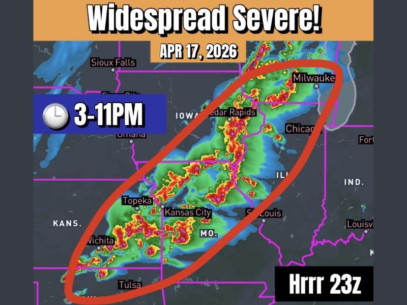
KANSAS CITY, MISSOURI — An active and potentially multi-faceted severe weather outbreak is forecast across a broad corridor stretching from Wisconsin into Oklahoma on April 17, 2026, with all modes of severe weather possible including intense EF-3 tornadoes, very large hail up to 4 inches, and QLCS tornadoes. The primary window of concern runs from 3 PM through 11 PM, with storms expected to ramp up significantly after 7 PM once low-level winds become fully established.
Discrete Supercells Expected First — Transitioning to Linear Mode After 7 PM
The event is forecast to begin with discrete supercells capable of producing very large hail and significant tornadoes during the afternoon hours. As the evening progresses, the storm mode is expected to transition into bowing and linear structures, bringing QLCS tornado potential into the picture — an evolution similar to how the Wednesday setup unfolded earlier in the week.
Storms are anticipated to ramp up considerably after 7 PM once the low-level jet becomes engaged, increasing both tornado and damaging wind potential across the entire affected corridor.
EF-3 Tornado Threat Highest on the Northern End Near the Surface Low
The most intense tornado threat is expected on the northern end of the outbreak zone, closer to the surface low pressure system. Forecasters indicated that intense EF-3 tornadoes are possible in this zone, covering areas from Milwaukee and Cedar Rapids southward through the Iowa and Illinois corridor.
The HRRR 23z model depicted a concentrated band of intense storm activity across this northern zone, with significant red and purple radar returns forecast across Iowa, Illinois, and into the Chicago region.
Up to 4-Inch Hail Possible on the Southern End Near Wichita and Tulsa
The southern portion of the outbreak zone — covering areas near Wichita, Tulsa, and the Kansas-Oklahoma border — carried a significant large hail threat. Initial supercells in this area are expected to be capable of producing very large hail, with stones potentially reaching 4 inches in diameter on the southern end of the corridor.
The HRRR model showed multiple intense storm clusters developing across Kansas, Missouri, and into Oklahoma during the 3 PM to 11 PM timeframe, with the Topeka, Kansas City, Wichita, and Tulsa areas all within the highlighted severe zone.
Full Outbreak Zone Covers Wisconsin Into Oklahoma from 3 PM to 11 PM
The complete area at risk spans a large multi-state corridor including Wisconsin, Illinois, Iowa, Missouri, Kansas, and Oklahoma. The outlined zone on the HRRR 23z forecast graphic encircled activity from Milwaukee in the northeast down through Tulsa in the south, covering a significant portion of the central United States.
Residents across all areas within this corridor were urged to have a way to receive warnings, know their safe shelter location, and remain weather-aware throughout the entire afternoon and evening of April 17, 2026. Stay with GordonRamsayClub.com for the latest weather updates and detailed forecast coverage.

Leave a Reply