
OKLAHOMA — A strong cold front and developing dryline are setting the stage for severe storms across the state this afternoon and evening, bringing threats of large hail, damaging winds, and localized flooding. Storms are expected to intensify quickly and move across central and eastern Oklahoma through tonight.
Storms Initiate in Southwest Oklahoma Late Afternoon
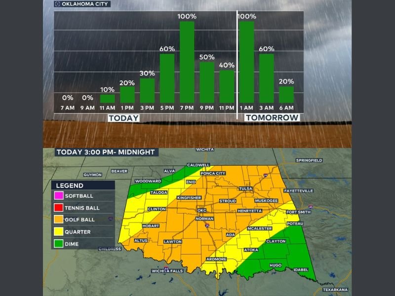
Storm development is expected to begin in southwest Oklahoma between 3 PM and 4 PM, forming ahead of the dryline. These storms will strengthen as they track northeast toward more populated areas.
By 5 PM to 8 PM, storms are expected to approach and move through the Oklahoma City metro, bringing the first round of severe weather impacts.
Large Hail and Damaging Winds Primary Threats
The main hazards with today’s storms include:
- Golf ball size hail or larger
- Wind gusts up to 70 mph
- Very heavy rainfall leading to localized flash flooding
While a tornado cannot be completely ruled out, the overall tornado threat is described as very low, especially once the cold front passes through.
Cold Front Shifts Storm Focus Into Evening and Overnight
As the evening progresses, the cold front will move south, triggering additional storms along its boundary. These storms will continue to produce hail and strong winds, especially across central and southeastern Oklahoma.
Once the front passes a given location, north winds will move in and the tornado threat will quickly diminish.
Overnight Storms Continue With Flooding Risk Increasing
Storm activity will continue into the night, shifting toward southern and southeastern Oklahoma, where the flooding threat becomes more significant.
Rainfall may persist into the early morning hours, with:
- Storms continuing through midnight and beyond
- Additional development in south-central Oklahoma overnight
- Rain gradually exiting the Oklahoma City area around 5 AM
- System clearing out of the state by midday Friday
Flooding Risk Highest in Southern and Southeastern Areas
The greatest concern for flooding will be in southern and southeastern Oklahoma, where repeated storms may lead to heavy rainfall totals and localized flash flooding. Residents are advised to avoid driving through flooded roads, especially where visibility is limited.
Active Weather Pattern Continues
Today’s setup reflects an active weather pattern driven by the interaction of a cold front and dryline. Conditions will remain dynamic through tonight before improving into Friday. Stay with GordonRamsayClub.com for the latest weather updates and detailed forecast coverage.

Leave a Reply