
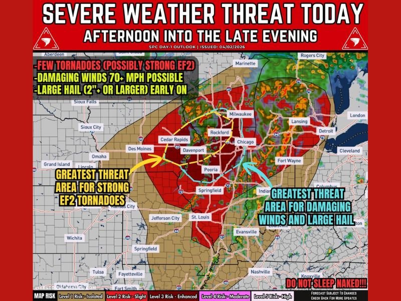
EASTERN IOWA, NORTHERN ILLINOIS, SOUTHERN WISCONSIN — Severe weather is expected to intensify later today, with storms developing through the afternoon and continuing into the evening across eastern Iowa, northern Illinois, and southern Wisconsin before pushing into Michigan overnight. The setup supports tornadoes, damaging winds over 70 mph, and large hail exceeding 2 inches, making this a high-impact weather day across the region.
Tornado Risk Highest With Early Supercells
Initial storms developing this afternoon may become discrete supercells, which carry the greatest tornado threat. A few tornadoes are possible, and some could become strong, reaching up to EF2 intensity.
The most concerning corridor extends from near Des Moines through the Quad Cities into northern Illinois, where conditions favor rotating storms capable of producing tornadoes before storms begin merging later in the day.
Damaging Winds Become Main Threat Into Evening
As storms evolve and begin to organize into lines by late afternoon and evening, the primary hazard will shift toward widespread damaging winds.
Wind gusts of 60 to 75+ mph are possible, especially as storms push eastward. These winds may continue well into the night, particularly as the system moves into Michigan, where impacts could persist even after storms weaken slightly.
Large Hail Risk Early Before Storms Merge
Before storms consolidate, early activity may produce large hail greater than 2 inches in diameter. This threat is highest during the initial development phase this afternoon when storms remain more isolated and intense.
Once storms merge into clusters or lines, the hail risk will decrease while wind damage becomes more dominant.
Timeline Shows Escalating Threat Through the Day
The progression of today’s severe weather follows a clear timeline:
- Morning to Early Afternoon: Ongoing rain and scattered storms
- Afternoon: New storms develop with supercell potential and tornado risk
- Late Afternoon to Evening: Storms merge into lines, increasing wind threat
- Evening to Overnight: Strong winds continue east into Michigan
This evolution highlights a transition from tornado and hail risk early to a widespread wind event later.
A High-Impact Weather Day Across the Midwest
Today’s setup combines multiple severe weather hazards with a long duration of impact across several states. The combination of tornado potential, damaging winds, and large hail makes this a situation that requires close attention throughout the day and into the night.
Residents are advised to remain weather-aware and ensure they have multiple ways to receive warnings, especially as conditions can change quickly during the afternoon and evening hours. Stay with GordonRamsayClub.com for the latest weather updates and detailed forecast coverage.

Leave a Reply