
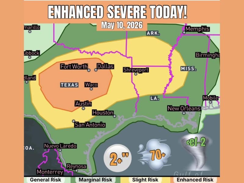
NORTH AND CENTRAL TEXAS — An Enhanced severe weather risk is in place today, May 10, 2026, across north and central Texas as a cold front rapidly surges southward forcing numerous storms in its wake. Very large hail exceeding 2 inches in diameter and strong winds over 70 mph are the primary hazards, with the Enhanced Risk core centered over a wide corridor covering Fort Worth, Dallas, Waco, Austin, Houston, and San Antonio. A brief tornado cannot be ruled out, with the best tornado chances concentrated along the Interstate 20 corridor from roughly Big Spring through the Dallas Fort Worth area.
What Is Driving Today’s Severe Weather
A rapidly surging cold front pushing southward across Texas is the primary driver behind today’s widespread severe weather threat. The fast-moving front is forcing up numerous storms across north and central Texas as it pushes through, creating the atmospheric conditions needed for very large hail and damaging wind-producing storms across a broad area of the state throughout the day.
Very large hail and strong winds are identified as the dominant hazard modes for today’s storm setup, with hail exceeding 2 inches in diameter and wind gusts over 70 mph both possible with the strongest storms moving through the Enhanced Risk zone.
Areas Inside the Enhanced Risk Zone
The Enhanced Risk orange zone is centered over a large swath of central Texas covering Fort Worth, Dallas, Waco, Austin, Houston, and San Antonio, making this a major population center threat affecting millions of Texas residents today. A broader Slight Risk yellow zone extends the threat outward to include Shreveport, New Orleans, and portions of Louisiana and Mississippi on the eastern edge of the severe weather outlook.
A Marginal Risk zone further surrounds the outer edges of the system, keeping communities from Lubbock through Amarillo on the western edge and extending toward Memphis and Birmingham on the northeastern edge within a general severe weather awareness zone for today.
Tornado Risk Exists Along I-20 Corridor
While tornadoes are not the primary mode for today’s setup on a synoptic level, a random brief tornado is always possible due to storm interactions or any storm that manages to avoid being undercut by the cold front too quickly. The best chance for any tornado activity is concentrated along the Interstate 20 corridor from roughly Big Spring through the Dallas Fort Worth area, where atmospheric conditions are most supportive of brief rotating storm activity. Any tornadoes that develop are expected to remain below EF-2 intensity.
What Texas Residents Must Do Today
All residents across Fort Worth, Dallas, Waco, Austin, Houston, San Antonio, and surrounding north and central Texas communities are urged to stay fully weather aware throughout today. Secure vehicles under cover before storms arrive to protect against large hail damage, keep weather alerts active on all devices, and be prepared to take immediate shelter if severe thunderstorm or tornado warnings are issued for your specific county today. Stay with GordonRamsayClub.com for the latest updates.

Leave a Reply