
ALABAMA — A First Alert Weather Day has been declared for Alabama as a significant severe weather system pushes through the state today, Wednesday May 6, 2026. The greater concern for severe weather arrives this afternoon and evening, with storms expected to develop west and northwest by 2 PM, the risk increasing across Central Alabama by 6 PM, and the tornado threat gradually shifting south overnight through 10 PM with stronger storms and localized flooding possible through midnight.
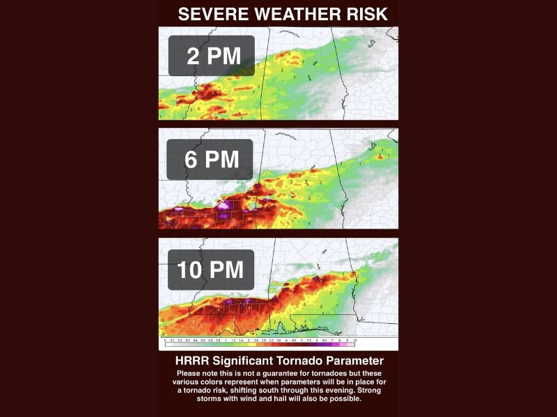
Hour by Hour Storm Timeline
The severe weather threat unfolds across Alabama in three distinct phases throughout today. Storms begin developing to the west and northwest by 2 PM, with HRRR tornado parameter guidance showing significant values already building across the western portions of the state during this initial phase.
By 6 PM the risk increases significantly across Central Alabama as the system pushes eastward, with the HRRR tornado parameter map showing extreme values concentrated across the central corridor at this hour. The 10 PM timeframe sees the tornado threat gradually shifting south overnight, though stronger storms and localized flooding could linger across Alabama through midnight before conditions begin to settle down.
What Hazards Are on the Table
Wind, hail, tornadoes, and localized flooding are all on the table for Alabama today. South to southwest wind gusts over 20 mph will be present throughout the day even outside of storm activity, adding an additional layer to the overall weather hazard picture.
The tornado risk is being taken seriously by meteorologists, who noted that HRRR significant tornado parameter guidance supports the need to be weather alert starting in the early afternoon hours beginning in the northwest. While this is not expected to be a major outbreak-type setup, forecasters were firm in their reminder that it only takes one storm to cause devastating damage.
Not a Major Outbreak But Still Dangerous
Meteorologists were careful to clarify that today’s event is not anticipated to be a major tornado outbreak across Alabama. However, the atmospheric conditions are clearly supportive of organized severe storm development, and the wind, hail, and flooding threats will continue until the heaviest activity shifts south later tonight.
The good news is that calmer weather is expected to return by tomorrow as the system moves through and the threat gradually settles down after midnight.
Bottom Line for Alabama Residents
Keep a close eye on weather conditions throughout this afternoon and evening and make sure you are ready to act immediately if warnings are issued for your county. Have your shelter plan finalized now, keep weather alerts fully active on all devices, and do not wait until storms arrive to take the threat seriously today. Stay with GordonRamsayClub.com for the latest updates.

Leave a Reply