
NORTHEAST UNITED STATES AND NEW ENGLAND — Rain showers and clouds are dominating Mother’s Day across the Northeast United States and New England on Sunday, with early morning showers being followed by more shower activity this afternoon and evening. Temperatures are holding in the 60s across northern areas and climbing to the mid 70s further south, with radar showing active green returns spread across a wide corridor from New York and Boston through Vermont, Maine, Montreal, and into the Maritime provinces of Canada.
What the Radar Shows This Morning
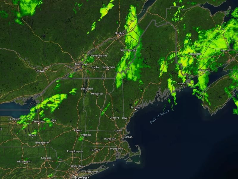
Active radar returns are visible across the entire Northeast and New England region Sunday morning, with green shower activity spread widely from New York City and Boston northward through Albany, Hartford, Providence, Portland, Burlington, and Montreal. The heaviest and most widespread activity is concentrated across Maine, New Brunswick, and the Maritime region of eastern Canada, where dense green returns are clustered across a large area stretching from Fredericton through Moncton and toward Halifax.
Scattered shower activity is also present across upstate New York, Vermont, New Hampshire, and portions of Quebec as the rain-bearing system continues moving through the region throughout the day.
Temperature Expectations Sunday
Temperatures across the Northeast are running on the cooler side of what would be expected for mid May, with northern areas including upstate New York, Vermont, Maine, and Quebec struggling to get out of the 60s throughout the day. Southern portions of the region from New York City through Hartford, Providence, and Boston will see slightly warmer conditions with readings climbing into the mid 70s during any breaks in the cloud cover.
Meteorologists noted that while the cool and cloudy conditions are not ideal, they are far from a complete washout weekend, with some sunshine potentially burning through the cloud cover between shower rounds during the afternoon hours.
More Rain Coming Wednesday Into Thursday
The unsettled weather pattern is not ending after Sunday. More rain is expected to return to the Northeast and New England region Wednesday into Thursday, keeping temperatures on the cooler side with highs continuing to struggle to break out of the 60s through much of the week.
However, the CPC 6 to 10 day and 8 to 14 day outlooks are pointing toward slightly above normal temperatures toward the tail end of May, suggesting that genuine warmth is on its way for the region as the month progresses toward its final weeks. Stay with GordonRamsayClub.com for the latest updates.

Leave a Reply