
CHICAGO, ILLINOIS — The Storm Prediction Center has upgraded the tornado risk for northern Illinois Thursday June 11, with EF3-plus tornadoes now explicitly possible across a corridor covering Chicago, Rockford, Sycamore, Joliet, Peoria, and Bloomington as an exceptionally volatile parameter space builds behind morning storms.
SPC Upgrades Tornado Risk With EF3 Tornadoes Now Possible
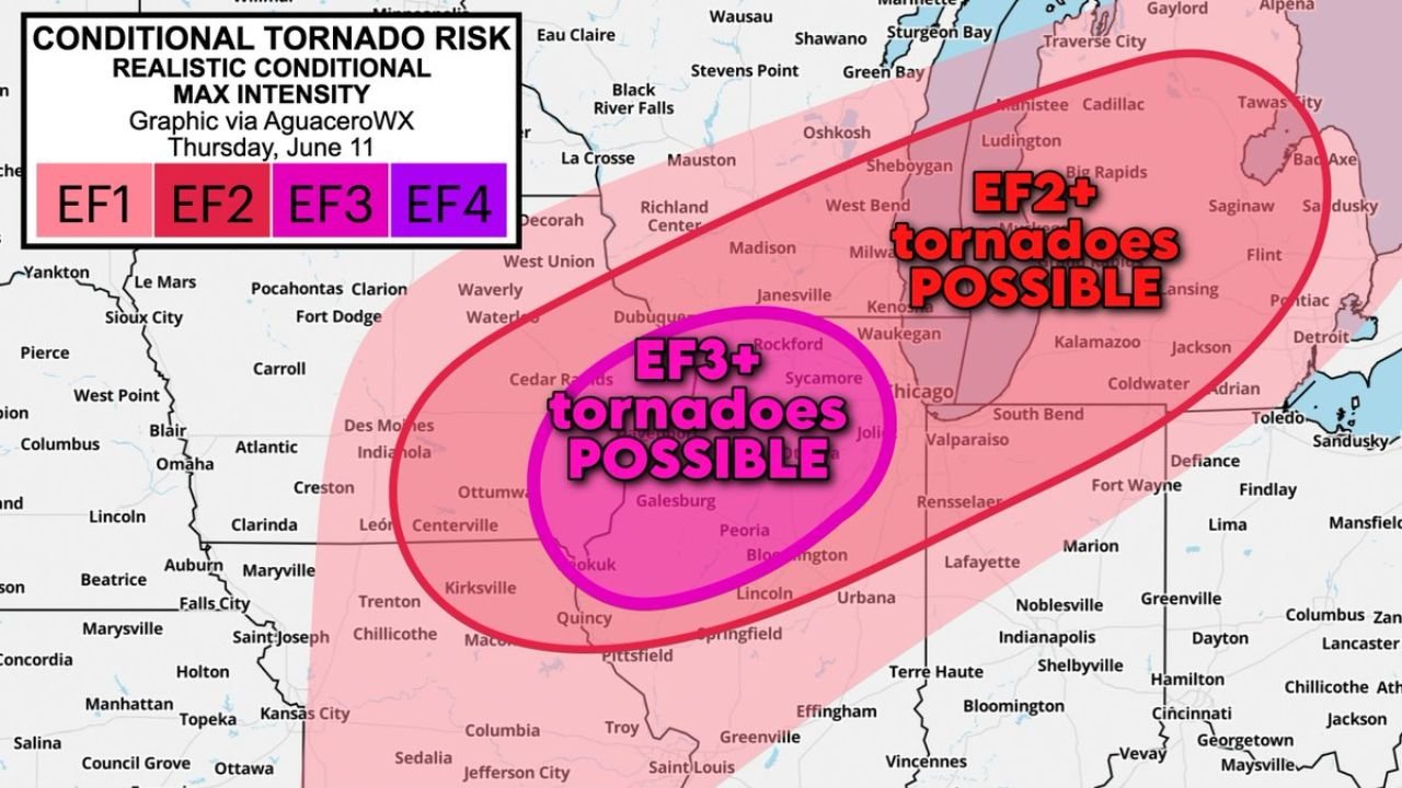
The AguaceroWX conditional tornado risk graphic valid Thursday June 11 shows a magenta EF3-plus tornado possible zone centered directly over northern Illinois including Chicago, Rockford, Waukegan, Galesburg, Peoria, and Bloomington. A broader pink EF2-plus zone surrounds that core, extending the significant tornado threat across Milwaukee, Kenosha, Kalamazoo, South Bend, Fort Wayne, and into western Indiana.
The upgrade reflects a volatile overlap of tornado ingredients including robust wind shear, exceptional thunderstorm fuel, and a hot humid air mass reheating beneath partial sun behind morning storms.
Storm Mode Will Determine Tornado Outcome
Forecasters are flagging storm mode as the critical wildcard for Thursday’s tornado potential. If storms can organize as discrete supercells, several strong tornadoes are possible across northern Illinois. If the convection instead consolidates into a squall line, the threat shifts toward primarily straight-line damaging winds with a few quick-hitting embedded tornadoes.
One limiting factor noted is mid-level lapse rates, where warm mid-levels could slow surface air from rising into storms and reduce overall intensity. Water-loaded high-precipitation storm structures are also a possibility that could further complicate the tornado threat.
Multiple Warning Methods Essential Given Rapid Threat Potential
The combination of robust wind shear and exceptional instability means any storm that successfully organizes Thursday afternoon could intensify rapidly. Forecasters are urging residents across northern Illinois and the Chicago metro to have multiple ways to receive warnings before storms develop.
Anyone in the EF3-plus zone covering Chicago, Rockford, Peoria, and Bloomington should treat Thursday as a life-safety severe weather day and be prepared to shelter immediately when warnings are issued.
Stay with GordonRamsayClub.com for the latest updates.

Leave a Reply