
WASHINGTON, DC — Temperatures across the Lower 48 will run significantly above average this week, with the northern and central Plains facing highs running 20 to 25 degrees above normal tomorrow and the Northeast expected to see temperatures climb well into the 90s by Thursday, as the National Weather Service issues an Extreme Heat Planning Timeline urging residents across the affected regions to prepare now for the dangerous heat ahead.
Northern and Central Plains Temperatures Running 20 to 25 Degrees Above Average Tomorrow
The most dramatic temperature departures from normal this week will be felt across the northern and central Plains, where high temperatures are expected to run 20 to 25 degrees above the seasonal average tomorrow. This magnitude of temperature departure represents an extraordinary heat event for the region, with communities across the Dakotas, Nebraska, Kansas, and surrounding Plains states facing dangerously hot conditions that will stress vulnerable populations, livestock, and agricultural operations already dealing with significant soil moisture deficits across the region.
Northeast Temperatures Climbing Well Into the 90s by Thursday
By Thursday June 11, the heat surge spreads eastward into the Northeast with temperatures expected to climb well into the 90s across the region. The combination of 90 plus degree temperatures and elevated summer humidity across the Northeast will create dangerous heat index values for major population centers from Washington DC and Philadelphia through New York City and Boston. Urban heat island effects will amplify the health risk across densely populated Northeast cities as the heat event peaks during the Thursday timeframe.
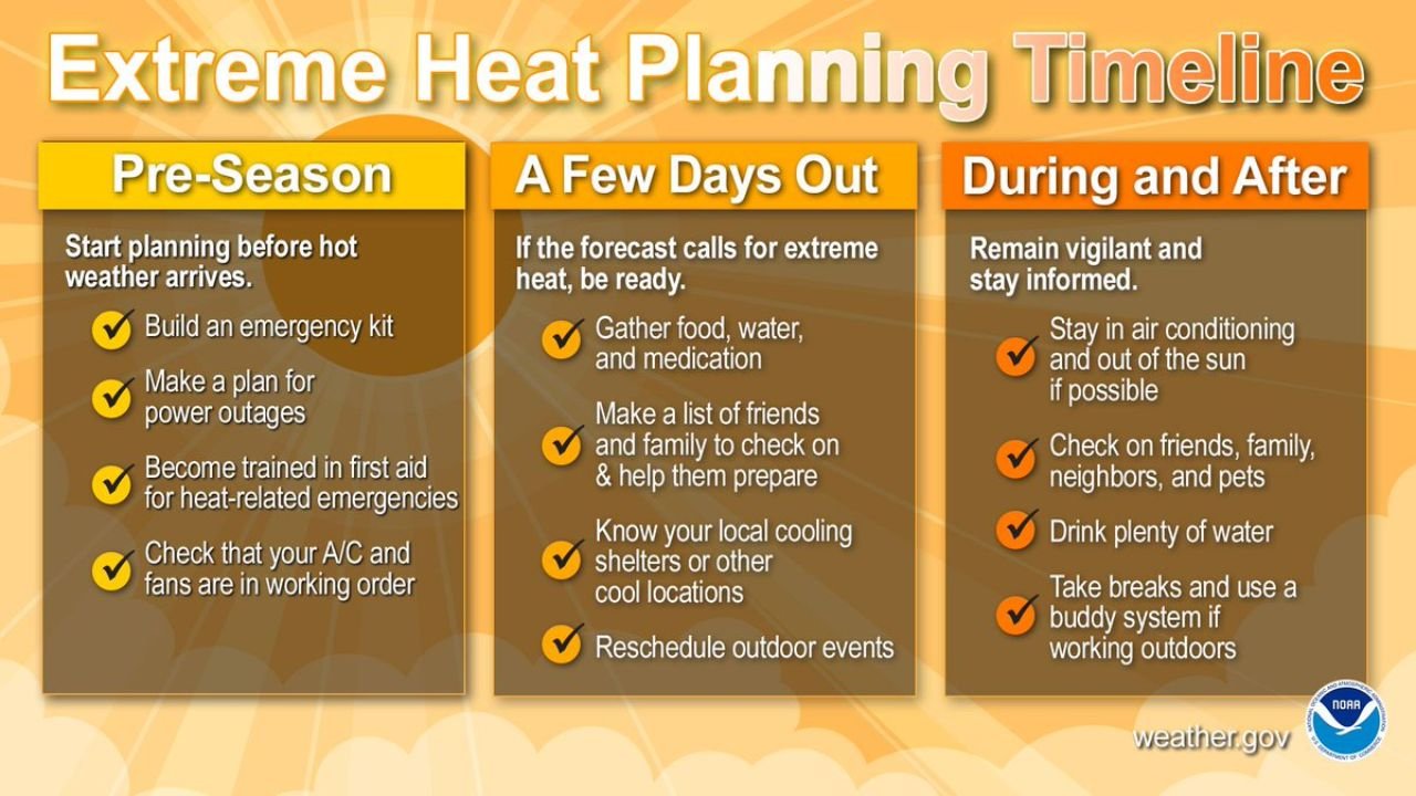
NWS Extreme Heat Planning Timeline Urges Three Stage Preparation Approach
The National Weather Service Extreme Heat Planning Timeline outlines a three-stage approach for residents preparing for extreme heat events. During the pre-season phase, residents should build an emergency kit, make a plan for power outages, become trained in first aid for heat-related emergencies, and check that air conditioning and fans are in working order. A few days out from an extreme heat event, residents should gather food, water, and medication, make a list of friends and family to check on, know local cooling shelter locations, and reschedule outdoor events. During and after the heat event, staying in air conditioning, drinking plenty of water, checking on friends, family, neighbors, and pets, and using a buddy system when working outdoors are all critical safety steps.
Residents Across Plains and Northeast Should Act on Heat Safety Measures Immediately
With temperatures running 20 to 25 degrees above normal across the Plains and 90 plus degree heat arriving in the Northeast by Thursday, residents across both regions should begin implementing NWS heat safety recommendations immediately and visit weather.gov for additional extreme heat preparedness resources before dangerous conditions arrive this week.
Stay with GordonRamsayClub.com for the latest updates.

Leave a Reply