
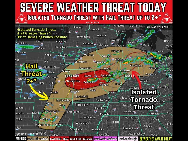
MIDWEST AND CENTRAL PLAINS — A severe weather threat is in place today, May 4, 2026, across parts of the Midwest and central and southern Plains, bringing large hail greater than 2 inches, brief damaging winds, and a low but real isolated tornado risk to millions of residents. The threat spans a wide area from Wisconsin, Iowa, and Illinois through eastern Kansas and Missouri and extends south along the dryline into Oklahoma and north Texas during the afternoon and evening hours.
Primary Threats Breakdown
Three key hazards are driving today’s severe weather concern across the affected region. Large hail is the primary risk, particularly across eastern Kansas into Oklahoma, where hail greater than 2 inches in diameter is possible with stronger storms. Damaging winds are also expected, especially with storms developing along the front as activity increases into the evening hours. A low and conditional tornado risk rounds out the threat, meaning isolated tornadoes cannot be ruled out across portions of the risk zone.
Storm Timing Throughout the Day
The severe weather will unfold in stages across the region throughout the day. During the afternoon, storms are expected to develop first across Wisconsin, Iowa, and Illinois. Moving into the late afternoon and evening, storm potential increases significantly across eastern Kansas into Missouri, where the better severe threat is concentrated and large hail becomes the primary concern.
By evening, isolated storms may also fire along the dryline stretching from Kansas into Oklahoma and north Texas. Any storm that develops along the dryline could organize into a supercell capable of producing large to very large hail alongside strong wind gusts.
Where the Strongest Storms Are Expected
The core of the severe threat sits across eastern Kansas into Missouri, highlighted in the enhanced risk zone on today’s outlook map. This corridor carries the highest concentration of large hail potential and the best overlap of atmospheric instability and wind shear needed to support strong storm development throughout the evening hours.
Oklahoma is also included in the hail threat, and storms pushing south along the dryline into north Texas during the evening could produce supercell activity with significant hail and gusty winds.
What Residents Should Do Today
All residents across Wisconsin, Iowa, Illinois, Kansas, Missouri, Oklahoma, and north Texas within the outlined risk areas are urged to stay weather aware throughout the entire afternoon and evening. When thunder roars, go indoors immediately and do not wait for conditions to visibly deteriorate before seeking shelter. Stay with GordonRamsayClub.com for the latest updates.

Leave a Reply