
MIAMI, FLORIDA — A growing and increasingly concerning tropical weather signal is emerging for the Gulf of Mexico and western Caribbean beginning late next week, as multiple overlapping equatorial wave signals including MJO, Kelvin, and Rossby waves converge near 90 degrees west longitude, activating the Central American monsoon and creating potential for a messy cyclone to develop and ultimately approach the Gulf Coast around the June 18 timeframe.
Multiple Equatorial Wave Signals Overlapping Near 90W Creating Active Tropical Environment
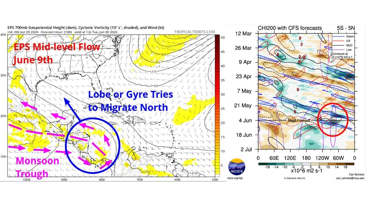
The Central American monsoon is becoming increasingly active as multiple equatorial wave signals converge near 90 degrees west longitude beginning next week. CFS CHI200 forecast data from NCICS updated June 5, 2026 shows a significant clustering of Kelvin wave, Equatorial Rossby wave, and MJO signals circled in red near the 120W to 60W longitude band during the June 4 through June 18 timeframe. This overlap of multiple tropical wave forcing mechanisms simultaneously is a classic precursor pattern for enhanced convective organization and tropical development potential across the western Caribbean and Gulf of Mexico region.
Monsoon Trough Lobe or Gyre Attempting to Migrate Northward Into Western Caribbean or Southern Gulf
EPS 700mb Geopotential Height and Cyclonic Vorticity analysis initialized 00Z June 5, 2026 and valid 12Z June 9, 2026 via Tropical Tidbits shows the monsoon trough positioned over Central America with a lobe or gyre attempting to migrate northward into the western Caribbean or southern Gulf of Mexico. The blue circle on the EPS mid-level flow map highlights this cyclonic vorticity feature near the Central American coastline trying to push northwestward, with pink arrows indicating the monsoon flow pattern surrounding the developing feature. This northward migration scenario is one that forecasters historically associate with potential for messy and disorganized cyclone development as the feature encounters the Gulf environment.
Scenario Often Creates Messy Cyclone Potential Approaching Gulf Coast Late Next Week
Forecasters note that the scenario of an eastern monsoon trough lobe or weak gyre migrating northwestward into the western Caribbean or southern Gulf is one that often creates potential for messy cyclones to develop and ultimately approach the Gulf Coast. While any system that develops in this early season environment would likely be a disorganized rain-maker rather than a powerful hurricane due to wind shear and dry air limitations, the rainfall and flooding potential from a slow-moving Gulf disturbance could still be significant for Gulf Coast communities if the scenario materializes around the June 18 window.
Gulf Coast Residents From Texas Through Florida Should Begin Monitoring Tropical Outlooks
With multiple equatorial wave signals overlapping and a monsoon gyre attempting to migrate northward toward the Gulf, residents across the Texas, Louisiana, Mississippi, Alabama, and Florida Gulf Coast should begin monitoring official National Hurricane Center tropical weather outlooks closely as the late June timeframe approaches and model guidance continues to evolve on this developing tropical threat.
Stay with GordonRamsayClub.com for the latest updates.

Leave a Reply