
BIRMINGHAM / ALABAMA — A First Alert Weather Day has been declared across Alabama for Tuesday as a two-round storm system moves through the state — bringing rain and potentially strong to severe storms during the morning commute followed by a second and potentially more dangerous round of storms after 4 p.m. that could turn severe if the atmosphere has adequate time to recover through the midday hours.
Morning Round Moving South Through Late Morning
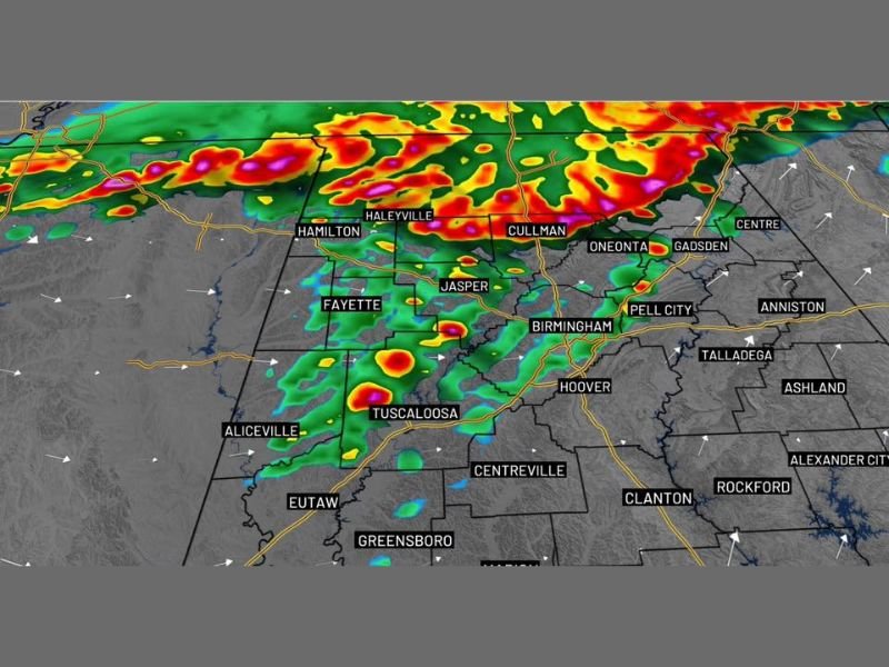
A line of rain and storms is already moving in from the north Tuesday morning and pushing steadily southward through the late morning hours. Radar at 5:00 a.m. showed heavy and active storm cells moving through a corridor covering Hamilton, Haleyville, Cullman, Oneonta, Gadsden, Jasper, Fayette, Birmingham, Pell City, Tuscaloosa, and surrounding communities across North and Central Alabama.
While a few storms within the morning line could be strong to severe — particularly across northern Alabama early — forecasters expect the system to gradually weaken as it pushes southward through the late morning period. Drivers heading out during the morning commute should plan for the possibility of heavy rain and reduced visibility along major corridors.
What Happens at Midday Is the Critical Factor
The single most important variable shaping Tuesday’s overall severe weather potential is what happens during the late morning into midday transition period. If the morning storm line moves through efficiently and the wet weather clears out — giving the atmosphere time to recover and destabilize through the afternoon — the second round of storms developing after 4 p.m. could turn strong to severe.
However, if clouds and scattered showers hang around and persist well into the afternoon, the atmosphere will not have sufficient time to recover. In that scenario, the second round is more likely to produce a steady rain event with thunder tonight rather than organized severe storms. Forecasters are direct — what happens late morning into midday will determine how the severe risk plays out this evening.
Second Round Possible After 4pm — Severe Storms if Atmosphere Recovers
If conditions align for atmospheric recovery through the afternoon, the post-4 p.m. storm round carries real severe weather potential for Alabama communities. The timing places the highest risk period during the late afternoon and evening hours when destabilization would be at its peak.
Communities across the Birmingham metro, Tuscaloosa, Cullman, Gadsden, Anniston, Talladega, and surrounding Central Alabama areas fall within the zone that would be most impacted by a second round of organized severe storms Tuesday evening.
Multi-Day Rain Pattern Continues Through the Week
Tuesday’s storm activity is not isolated — rain chances continue overnight into Wednesday morning, with another round of storms possible Wednesday afternoon and evening depending on how the pattern evolves. The system shifts south on Thursday before more rain returns Friday into the start of the weekend. Cold and dry air finally pushes in by Sunday, with temperatures dropping back to the 40s by Sunday morning.
Forecasters noted that despite missing significant rainfall during the previous system, this multi-day pattern represents one of the better chances for meaningful rainfall accumulation across Alabama in quite some time. Stay with GordonRamsayClub.com for the latest updates.

Leave a Reply