
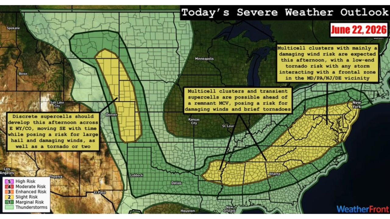
DENVER, COLO. — Another day of severe weather is on tap today, Monday, June 22, with dual Slight Risk level 2 of 5 areas covering two completely separate parts of the country simultaneously, from the Central High Plains of eastern Wyoming and Colorado all the way to the East Coast and Southeast.
Discrete Supercells to Fire Across Eastern Wyoming and Colorado
Discrete supercells are expected to develop across the higher terrain of eastern Wyoming and Colorado this afternoon, moving southeast with time and posing a risk for large to very large hail and damaging winds. The threat for a tornado or two appears greatest across western Nebraska and northeast Colorado as these initial supercells move off the terrain into richer moisture.
East Coast Frontal Zone Threatens Maryland, Pennsylvania, New Jersey, Delaware
Across the East Coast, multicell clusters are expected to develop along and near the Appalachians and push toward the coast, posing a risk for mainly damaging winds. A tornado or two will be possible near a frontal zone draped across the Maryland, Pennsylvania, New Jersey, and Delaware vicinity, making this corridor one to watch closely this afternoon and evening.
Southeast Watching MCV Ahead of Overnight Convection
Farther south across the Southeast, multicell clusters and transient supercells are possible ahead of a mesoscale convective vortex from overnight convection. This setup poses a risk for damaging winds and brief tornadoes across portions of the Southeast as the MCV tracks through the region.
Dual Slight Risk Covers Massive Stretch of the Country
Today’s dual Slight Risk areas cover an enormous stretch of the country simultaneously, from the High Plains of Wyoming and Colorado through Nebraska on one end, to the Mid Atlantic and Southeast on the other. Cities including Denver, Cheyenne, Kansas City, St. Louis, as well as New York, Philadelphia, and Atlanta all fall within or near the broader outlined risk areas today.
Stay with GordonRamsayClub.com for the latest updates.

Leave a Reply