
KANSAS CITY, MISSOURI — Two days out from Wednesday June 17, the SPC has hung a Level 3 of 5 severe weather risk over Missouri, Illinois, and Indiana, with forecasters describing this as an all-hazards day featuring strong tornadoes early from supercells before storms clump into one big line producing a long swath of 70 mph or greater damaging winds through the evening.
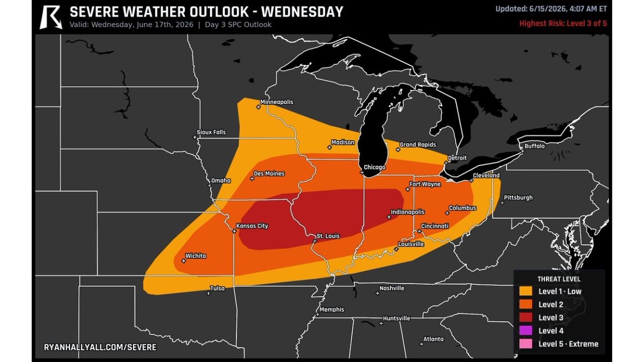
Level 3 Core Centered on Kansas City Through St. Louis
The Day 3 SPC outlook updated June 15 at 4:07 AM ET valid Wednesday June 17 shows a Level 3 red core centered directly over Kansas City and St. Louis. Level 2 orange shading surrounds the core, extending coverage from Wichita and Des Moines through Chicago, Indianapolis, Fort Wayne, Columbus, Cincinnati, and Louisville. Level 1 yellow shading pushes the broader severe footprint outward toward Minneapolis, Madison, Grand Rapids, Cleveland, and Buffalo.
This represents the highest risk designation issued on the Day 3 outlook and reflects significant forecaster confidence in an organized severe weather event across the central and eastern Midwest.
Strong Supercells Fire First Across Missouri and Illinois
The expected sequence for Wednesday begins with a few strong supercells firing across Missouri and Illinois during the afternoon hours. These discrete supercells carry the potential for strong tornadoes, representing the highest individual storm threat of the day before the convective mode begins to change.
As the evening progresses, those individual storms are expected to clump together into one large line that will plow eastward through Indiana and toward Ohio, transitioning the primary hazard from tornadoes toward widespread damaging winds.
Long Swath of 70 MPH Plus Winds Expected as Line Plows East
Once the consolidated line forms, gusts of 70 mph or more are expected along a long swath as the system tracks eastward through the evening hours. The all-hazards nature of Wednesday’s setup means residents across Missouri, Illinois, and Indiana need to prepare for both the tornado threat during the afternoon supercell phase and the damaging wind threat once the line organizes.
Forecasters note that plenty can still shift around with the placement and timing of this system, but the setup has captured significant attention even two days out. Residents across Kansas City, St. Louis, Chicago, and Indianapolis should monitor updates closely through Tuesday and into Wednesday.
Stay with GordonRamsayClub.com for the latest updates.

Leave a Reply