
CHICAGO, ILLINOIS — A significant and welcome cool pattern change is on the way for the Midwest, Great Lakes, and Northeast following this week’s hotter than normal conditions, as BAM Weather EPS 7 Day Mean 2 meter temperature anomaly data run June 8, 2026 at 00Z and valid June 15 through June 22, 2026 shows widespread cooler than normal temperatures of 2 to 4 degrees below average covering the entire central and eastern United States alongside an active weather pattern during the June 15 to 21 window.
Cool Pattern Change Arriving June 15 with Widespread Below Normal Temperatures Across Midwest and East
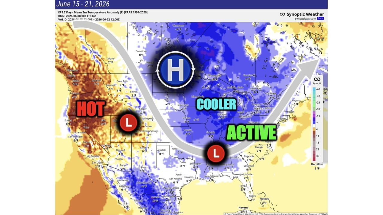
The EPS temperature anomaly map valid June 15 through June 22, 2026 shows a broad and expansive area of blue negative temperature anomalies covering the entire Midwest, Great Lakes, Ohio Valley, and Northeast corridor. Specific temperature departures include minus 4 degrees near Minneapolis, Sioux Falls, Omaha, Topeka, St. Louis, Denver, Colorado Springs, and Pittsburgh, minus 2 degrees near Chicago, Detroit, and Toronto, and near to slightly below normal across the broader Northeast from Ottawa and Buffalo through Boston and New York. This widespread cool pattern represents a dramatic contrast to the above normal and in some cases 20 to 25 degree above average temperatures that have been dominating the central US earlier this week.
Active Weather Pattern Accompanies the Cool Down Across Central and Eastern US
The cool pattern change arriving June 15 is accompanied by an active weather pattern across the central and eastern United States, as a surface low pressure system positioned over the south-central US drives storm activity across the region during the June 15 to 21 window. The active label on the BAM Weather map covering the southern Plains through the Ohio Valley and into the Southeast indicates a continued period of rain and storm activity associated with the cooler pattern, which could bring additional beneficial rainfall to drought-stressed areas of the Midwest and central Plains heading into the latter half of June 2026.
Hot Conditions Persist Across West While East Cools Down Dramatically
While the Midwest and East experience a dramatic cool down during the June 15 to 21 period, the western United States will remain hot with positive temperature anomalies of 7 to 9 degrees above normal indicated across Seattle, Portland, and the Pacific Northwest in orange and red shading on the EPS anomaly map. This east-west temperature contrast with a hot West and cool East is driven by the high pressure system positioned over central Canada and the upper Midwest, which will act as the primary driver of the below normal temperature pattern across the central and eastern United States during the June 15 to 21 timeframe.
Midwest and Northeast Residents Can Expect Relief from Heat Beginning Around June 15
After enduring above normal and in some cases extreme heat during the first half of June 2026, residents across Minneapolis, Chicago, Pittsburgh, and the broader Midwest and Northeast can look forward to a meaningful cool down and return to near or below normal temperatures beginning around June 15 as the pattern change arrives across the region.
Stay with GordonRamsayClub.com for the latest updates.

Leave a Reply