
MINNEAPOLIS, MINNESOTA — A significant severe weather outbreak is possible across the Midwest on Wednesday June 10, 2026, as Max Velocity Weather Categorical Outlook updated June 8, 2026 at 5:06 AM ET shows the Enhanced Risk zone shifting eastward to now include Minneapolis, Wausau, and Rockford in the core threat area, while Milwaukee, Chicago, and Kansas City have been added to the Slight Risk zone, with widespread damaging winds, very large hail, and strong tornadoes all possible across the region.
Enhanced Risk Now Covers Minneapolis, Wausau, and Rockford After Eastward Shift
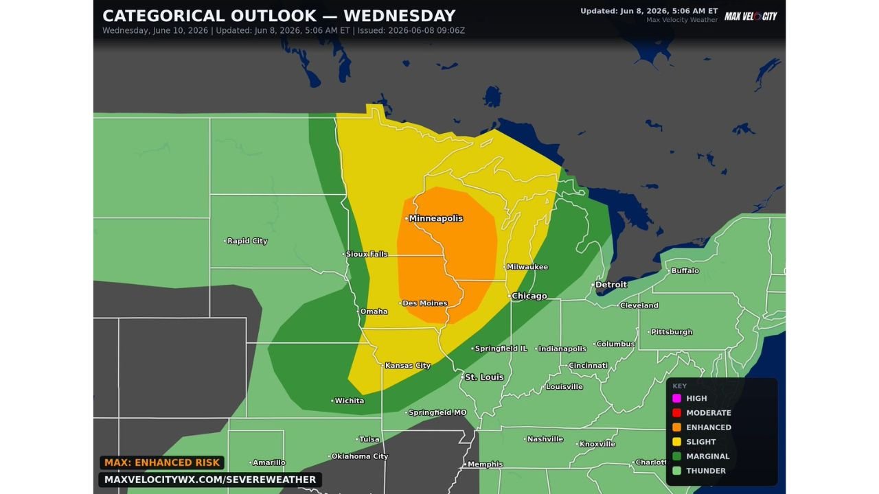
The Max Velocity Weather Categorical Outlook for Wednesday June 10 shows the Enhanced Risk Level 3 of 5 zone in orange now centered over Minneapolis, Des Moines, and the Rockford corridor following an eastward shift from earlier forecasts. The Enhanced Risk zone covers a substantial area from Sioux Falls and Omaha northeastward through Minneapolis and toward Wausau and Rockford, indicating forecasters have high confidence in widespread severe weather with multiple storm reports expected across this corridor. The Enhanced Risk designation reflects a setup capable of producing supercells and bowing segments with all severe hazards simultaneously active across the threat zone on Wednesday.
Slight Risk Expands East to Include Milwaukee, Chicago, and Kansas City
Outside the Enhanced Risk core, the Slight Risk Level 2 of 5 zone has expanded eastward to now include Milwaukee, Chicago, Kansas City, and St. Louis, representing a significant geographic expansion of the elevated severe weather threat compared to earlier outlooks. The Slight Risk corridor stretches from Kansas City and Omaha northward through Sioux Falls, Minneapolis, and extends eastward through Wausau toward Milwaukee and Chicago, covering an enormous population corridor across the central Midwest. Residents across all of these communities should treat Wednesday as a significant severe weather day requiring full preparation and alertness.
Widespread Damaging Winds, Very Large Hail, and Strong Tornadoes All Possible Wednesday
The hazard set for Wednesday June 10 across the Enhanced and Slight Risk zones includes the full complement of significant severe weather threats. Widespread damaging winds are expected as storms organize into bowing segments during the evening hours, very large hail will be possible during the initial supercell phase, and strong tornadoes are explicitly highlighted as a threat across the Enhanced Risk corridor. The combination of supercell and organized line storm modes makes this a multi-hazard event capable of producing impactful severe weather across a broad swath of the Midwest simultaneously.
Midwest Residents Must Prepare Now and Spread the Word About Wednesday Threat
Forecasters are explicitly urging residents to prepare now for a significant day of severe weather on Wednesday June 10 and to spread the word to alert friends and family across the affected region. Residents from Kansas City and Omaha through Des Moines, Minneapolis, Rockford, Milwaukee, and Chicago should finalize shelter plans and ensure multiple weather alert methods are fully active well before Wednesday storm development begins.
Stay with GordonRamsayClub.com for the latest updates.

Leave a Reply