
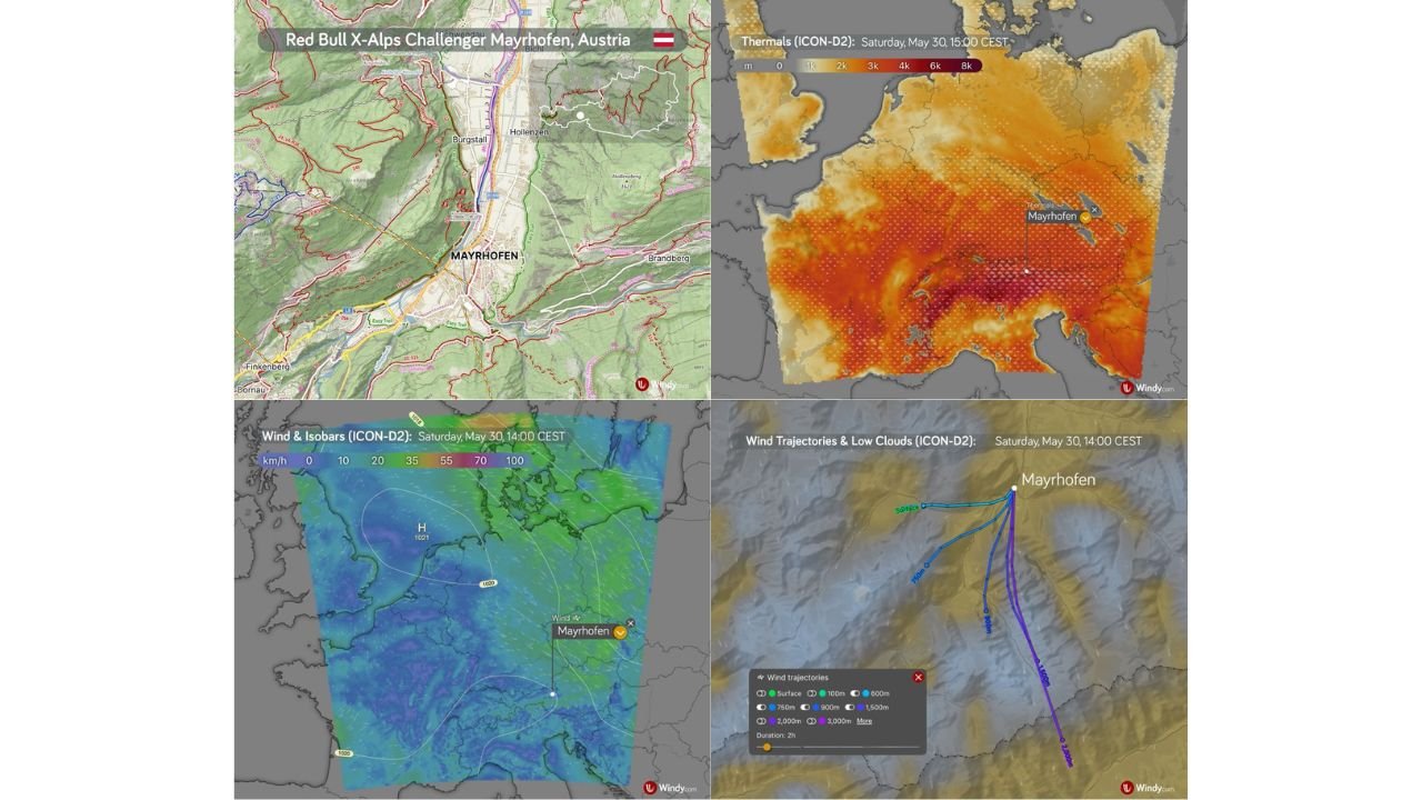
MAYRHOFEN, AUSTRIA — Saturday May 30, 2026 is shaping up as a conditionally flyable day for the Red Bull X-Alps Challenger Mayrhofen taking place in the Zillertal Valley of Austria, with a weakening ridge of high pressure extending from the southwest keeping morning conditions favorable for paragliding before increasing cumulus development and a possible thunderstorm raise caution levels through the afternoon hours.
Morning Conditions Favorable With Thermals Developing and Light Valley Winds
Valley temperatures at Mayrhofen are forecast to start around 12 degrees Celsius in the morning before climbing to approximately 26 degrees Celsius by the afternoon, providing the surface heating necessary to drive thermal development through the day. Valley winds are expected to remain light to moderate at mostly up to 12 km/h from the north through the morning hours, creating manageable flying conditions for athletes and recreational paragliders during the early part of the day.
Thermals should begin developing during the morning hours with the convective condensation level potentially rising to around 3,000 meters after midday, opening a solid flying window particularly from the morning through around noon according to the forecast briefing. The ICON-D2 thermals map valid at 15:00 CEST Saturday confirms active thermal development across the broader Alpine region with Mayrhofen sitting within the elevated thermal zone.
Afternoon Brings Cumulus Development, Local Showers and Possible Thunderstorm
The afternoon picture at Mayrhofen becomes progressively more complex as cumulus clouds develop over the surrounding Alpine terrain, bringing the risk of local showers and a thunderstorm that cannot be ruled out later in the day. Upper level winds at 700 hPa are forecast around 22 km/h from the north, later turning northwest and briefly strengthening, adding an additional layer of caution for high-altitude flying during the afternoon window.
The ICON-D2 Wind and Isobars map valid at 14:00 CEST Saturday shows a 1021 mb high pressure system positioned over northern Europe with light and generally calm surface winds across the Mayrhofen and broader eastern Alps corridor, confirming the relatively benign morning setup before afternoon convection develops.
Wind Trajectory Analysis Shows Northerly Flow Dominating the Zillertal Valley at Multiple Levels
The ICON-D2 Wind Trajectories and Low Clouds map valid at 14:00 CEST Saturday shows trajectories at multiple altitude levels from surface through 2,000 meters all tracking from a northerly direction through the Zillertal Valley toward Mayrhofen, confirming consistent northerly flow dominating across the valley at all forecast levels during the midday period. Athletes planning flight routes should account for this northerly trajectory pattern when planning cross-country lines from the Mayrhofen launch areas.
Stay with GordonRamsayClub.com for the latest updates.

Leave a Reply