
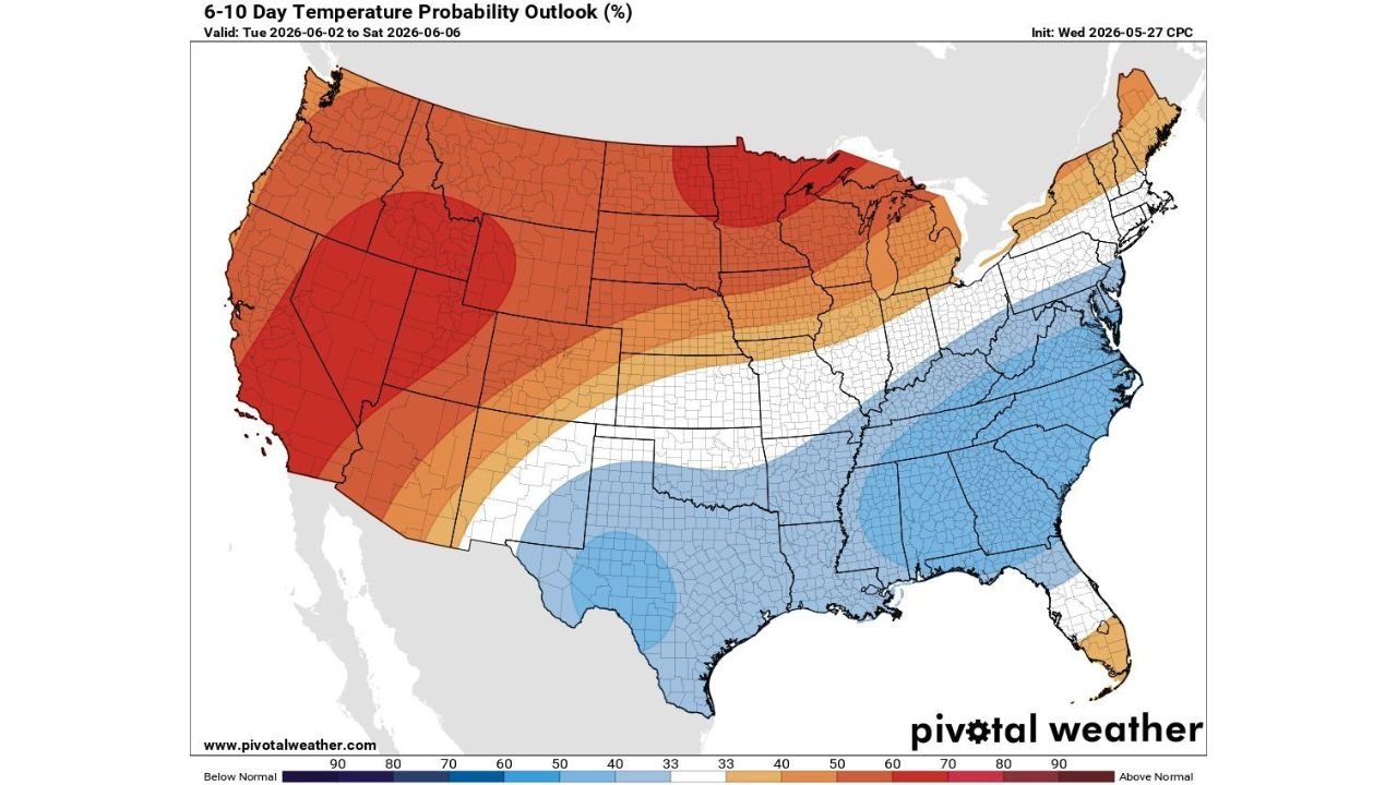
DENVER, COLORADO — A dramatically divided national temperature pattern is taking shape for the June 2 through June 6 timeframe, with the CPC 6 to 10 Day Temperature Probability Outlook initialized Wednesday May 27, 2026 showing a striking contrast between well above normal temperatures locked in across the West and upper Midwest and below normal temperatures covering the South, Southeast, and Gulf Coast regions during the same period.
Deep Red Above Normal Signal Covers California, Nevada, Wyoming and the Northern Plains
The most intense above normal temperature signal on the 6 to 10 Day outlook is concentrated in deep red shading across California, Nevada, Utah, Wyoming, Montana, and extending into the northern plains and upper Midwest. These deep red zones represent the highest probability tier on the above normal scale, indicating a very high confidence signal for temperatures running significantly above climatological norms across the western and north-central United States from June 2 through June 6.
A separate deep red core is also visible across Minnesota, Wisconsin, and the northern Great Lakes region, placing the Twin Cities and surrounding upper Midwest communities within a high probability above normal temperature zone during this same period. This aligns directly with the flash drought concern flagged by NOAA for the upper Midwest during the June 5 to 11 window, as above normal temperatures combined with below normal rainfall accelerate moisture depletion across the region.
Blue Below Normal Signal Covers Texas, the Gulf Coast and the Entire Southeast
In sharp contrast to the warm western pattern, a broad blue below normal temperature signal covers the entire southeastern quadrant of the country from Texas and Oklahoma eastward through Louisiana, Mississippi, Alabama, Georgia, Tennessee, and the Carolinas. The deepest blue shading is concentrated over central and south Texas where below normal temperatures carry the highest probability during the June 2 to 6 period.
This below normal temperature signal across the South and Southeast reflects the continued influence of Gulf moisture and cloud cover associated with the active and wet pattern that has dominated the region through late May, keeping temperatures suppressed relative to what would be expected for early June across the Gulf Coast and Southeast states.
Near Normal Temperatures Create a Transition Zone Across the Central United States
A transition band of near normal temperatures shown in white shading cuts diagonally across the central United States from the Texas panhandle northeastward through Kansas, Missouri, Indiana, and Ohio, creating a clear dividing line between the warm western pattern and the cooler southeastern pattern on the national temperature probability map.
Residents across the West and upper Midwest should prepare for a notably warm early June period while the South and Southeast can expect temperatures running modestly below normal through the June 2 to 6 timeframe.
Stay with GordonRamsayClub.com for the latest updates.

Leave a Reply