
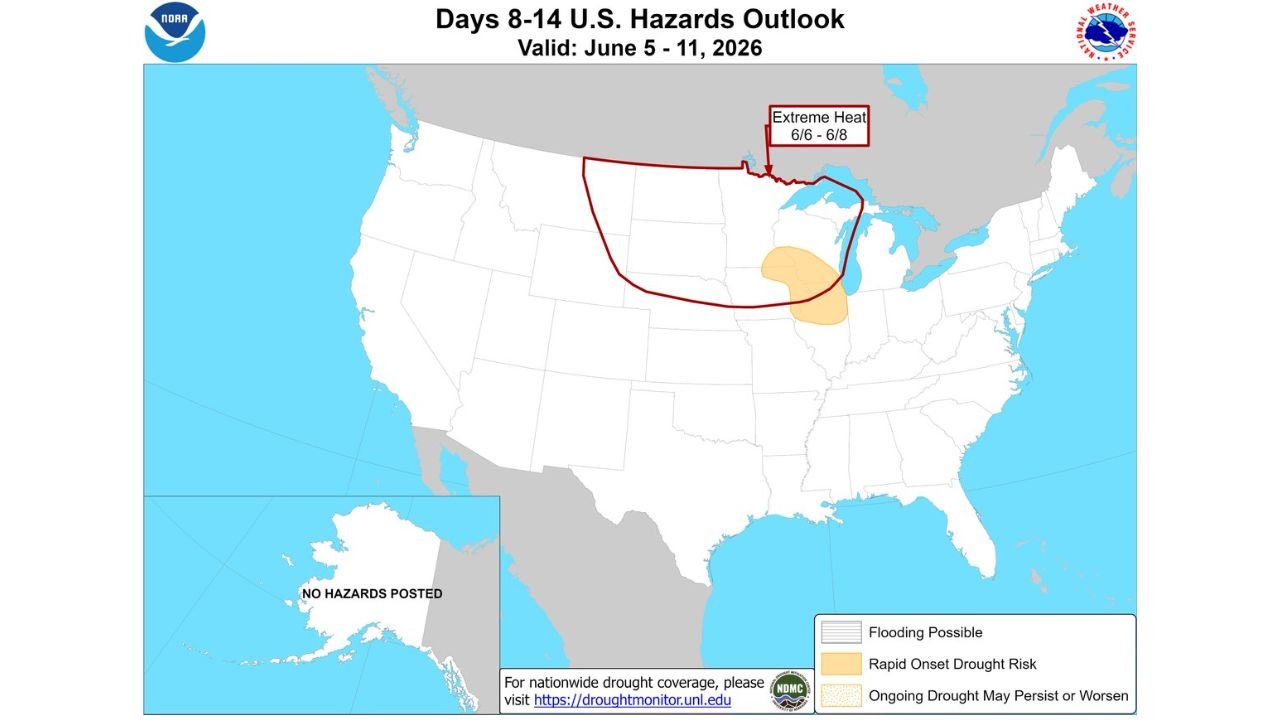
MINNEAPOLIS, MINNESOTA — NOAA’s Climate Prediction Center has released its Days 8 to 14 U.S. Hazards Outlook on May 28, 2026 at 3:00 PM EDT, flagging a Rapid Onset Drought Risk for parts of Minnesota, Iowa, Wisconsin, and Illinois between June 5 and June 11, 2026, with an Extreme Heat designation also active across the northern plains from June 6 through June 8 serving as a key contributing factor to the potential flash drought development.
Rapid Onset Drought Risk Zone Covers Minnesota, Iowa, Wisconsin and Illinois June 5 to 11
The CPC Days 8 to 14 Hazards Outlook shows a tan shaded Rapid Onset Drought Risk zone centered across the upper Midwest, covering a focused area encompassing parts of Minnesota, Iowa, Wisconsin, and Illinois during the June 5 to 11 valid period. This designation indicates that atmospheric and soil moisture conditions are expected to deteriorate rapidly enough over this timeframe that drought conditions could develop or intensify quickly across the impacted region.
Flash drought is a particularly dangerous type of drought because it develops over days to weeks rather than months, catching agricultural operations, water managers, and communities off guard without the typical warning period associated with conventional drought development. The combination of below-normal rainfall and above-normal temperatures can accelerate soil moisture depletion rapidly under flash drought conditions.
Extreme Heat Moving Into the Region June 6 Through June 8 Accelerates Flash Drought Risk
The same CPC outlook depicts an Extreme Heat designation valid from June 6 through June 8 across a broad zone outlined in red covering the northern plains, Upper Midwest, and extending into southern Canada. This Extreme Heat signal is a critical component of the flash drought threat, as extreme temperatures dramatically accelerate evapotranspiration rates and soil moisture loss across the region during the same window when rainfall is expected to be below normal.
Forecasters note that extreme heat moving into the region is a significant factor in flash drought development, reinforcing the seriousness of the combined hazard outlook for the upper Midwest heading into early June.
Flooding Possible Zone Also Outlined Across Northern Plains and Upper Midwest Region
The outlook also shows a Flooding Possible zone outlined in red across the northern plains and upper Midwest, covering portions of the Dakotas, Nebraska, Minnesota, and extending into southern Canada. This flooding designation reflects a separate precipitation-related hazard that may affect portions of the region during the same June 5 to 11 period, creating a complex and multi-hazard weather environment across the upper Midwest heading into early June.
Farmers, water resource managers, and residents across Minnesota, Iowa, Wisconsin, and Illinois should monitor drought and heat forecasts closely as the June 5 to 11 window approaches.
Stay with GordonRamsayClub.com for the latest updates.

Leave a Reply