
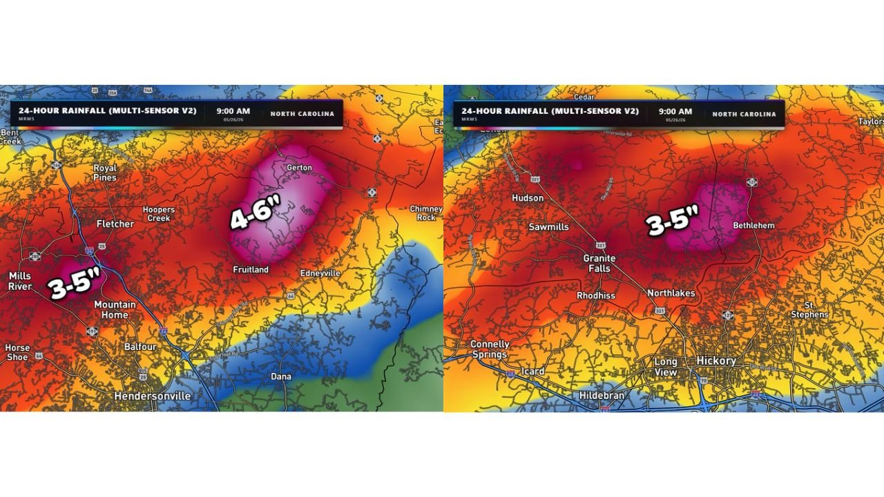
GRANITE FALLS, NORTH CAROLINA — Flash flooding has struck multiple communities across western North Carolina over the past 24 hours, with Multi-Sensor radar estimates valid at 9:00 AM on May 26, 2026 showing rainfall totals of 3 to 6 inches concentrated across two distinct heavy rain cores centered near Granite Falls and the Hendersonville and Gerton corridor, prompting serious localized flooding concerns across both areas.
Granite Falls and Bethlehem Corridor Records 3 to 5 Inches in 24 Hours
The first Multi-Sensor V2 24-hour rainfall map shows a deep pink and purple core centered between Granite Falls and Bethlehem in the Catawba Valley region, where radar estimates indicate 3 to 5 inches of rainfall accumulated over the 24-hour period ending at 9:00 AM May 26, 2026. The intense rainfall footprint extends outward in all directions with red and orange shading covering Hudson, Sawmills, Rhodhiss, Northlakes, and the broader Hickory metro area.
The rapid rate at which this rainfall fell is the primary driver of the localized flooding, as fast runoff from heavy downpours overwhelmed drainage infrastructure across the impacted communities before water levels in streams, creeks, and lakes could respond significantly.
Gerton and Mills River Area Sees the Highest Totals at 4 to 6 Inches
The second rainfall map focused on the Hendersonville region shows an even more intense rainfall core centered near Gerton, where radar estimates are indicating 4 to 6 inches of rainfall over the same 24-hour period. This represents the highest observed totals across the entire two-map dataset and places the Gerton area at the top of the rainfall distribution across western North Carolina overnight.
The Mills River and Mountain Home corridor just west of Hendersonville recorded 3 to 5 inches, keeping the entire Henderson County foothills zone well within the heavily impacted area. Fruitland, Edneyville, Fletcher, and Balfour are also sitting within the orange and red rainfall footprint on the Hendersonville area map.
Stream and Creek Levels Stable But Rapid Runoff Created Immediate Flash Flood Threat
Despite the significant rainfall totals, forecasters note that streams, creeks, and lakes across the region had plenty of room to absorb the incoming water, keeping those levels relatively stable through the event. The primary flooding concern was the speed at which the rain fell rather than cumulative river rise, with rapid surface runoff creating immediate localized flash flooding across roads and low-lying areas in both impacted zones.
Both the Granite Falls corridor and the Hendersonville area remain areas to watch closely for additional rainfall today and tomorrow as the wet pattern continues across western North Carolina.
Stay with GordonRamsayClub.com for the latest updates.

Leave a Reply