
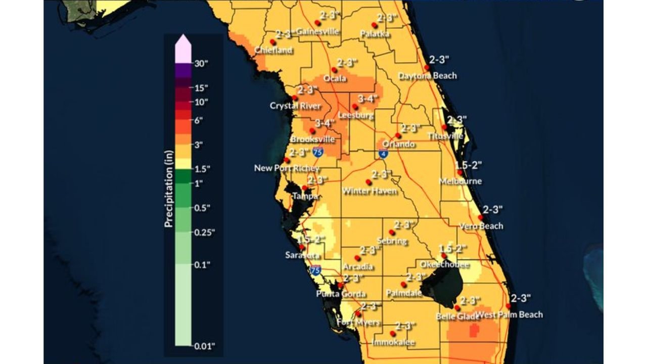
TAMPA, FLORIDA — A persistently stormy and wet six-day stretch is locked in across west central and southwest Florida, with the National Weather Service Tampa Bay office issuing a 6-Day Forecast at 5:00 AM EDT Tuesday May 26, 2026 showing daily thunderstorm chances ranging from 30 to 80 percent through Monday June 1, accompanied by widespread rainfall totals of 2 to 4 inches across the majority of the state.
NWS Tampa Bay 6-Day Rainfall Forecast Shows 3 to 4 Inch Totals Across Crystal River, Leesburg and Brooksville
The NWS Tampa Bay 6-Day Forecast Rainfall Amounts map, valid from 8:00 AM Tuesday May 26 through 8:00 AM Monday June 1, 2026, shows the highest projected totals concentrated in the Crystal River, Leesburg, and Brooksville corridor where 3 to 4 inch accumulations are forecast over the six-day period. This area sits within the deeper moisture corridor that forecasters expect to tap into as the pattern evolves through the week.
Across the broader central Florida region including Orlando, Ocala, Gainesville, and the Tampa metro, totals of 2 to 3 inches are projected, with the orange shading covering the majority of the peninsula reflecting a consistent and widespread rainfall footprint through June 1.
Thunderstorm Chances Climb to 70 to 80 Percent Saturday and Sunday as Deeper Moisture Arrives
The NWS Tampa Bay 6-Day Forecast chart shows a clear escalation in storm coverage as the week progresses. Today and Wednesday carry 30 to 70 percent thunderstorm chances, with temperatures reaching highs of 88 to 94 degrees Fahrenheit today and 87 to 92 degrees Wednesday.
Thursday and Friday see storm probabilities climbing to 40 to 80 percent as mostly cloudy skies take over, with highs dropping slightly to 86 to 90 degrees. The pattern reaches its most active phase on Saturday and Sunday when storm chances jump to 70 to 80 percent and 60 to 80 percent respectively, as deeper Caribbean moisture fully arrives and fuels numerous thunderstorms at almost any time of day.
Locally Heavy Rainfall Possible as Deeper Moisture Taps Into the Region Later This Week
Forecasters note that while today will be similar to Monday with scattered to numerous mainly afternoon and evening thunderstorms, the pattern will intensify over the next few days as deeper moisture arrives. This will lead to more numerous showers and thunderstorms firing at almost any time rather than being limited to the typical afternoon and evening window.
Locally heavy rainfall will be possible across the region through the end of the month, keeping flooding concerns active for low-lying areas across the Tampa Bay region and central Florida peninsula.
Stay with GordonRamsayClub.com for the latest updates.

Leave a Reply