
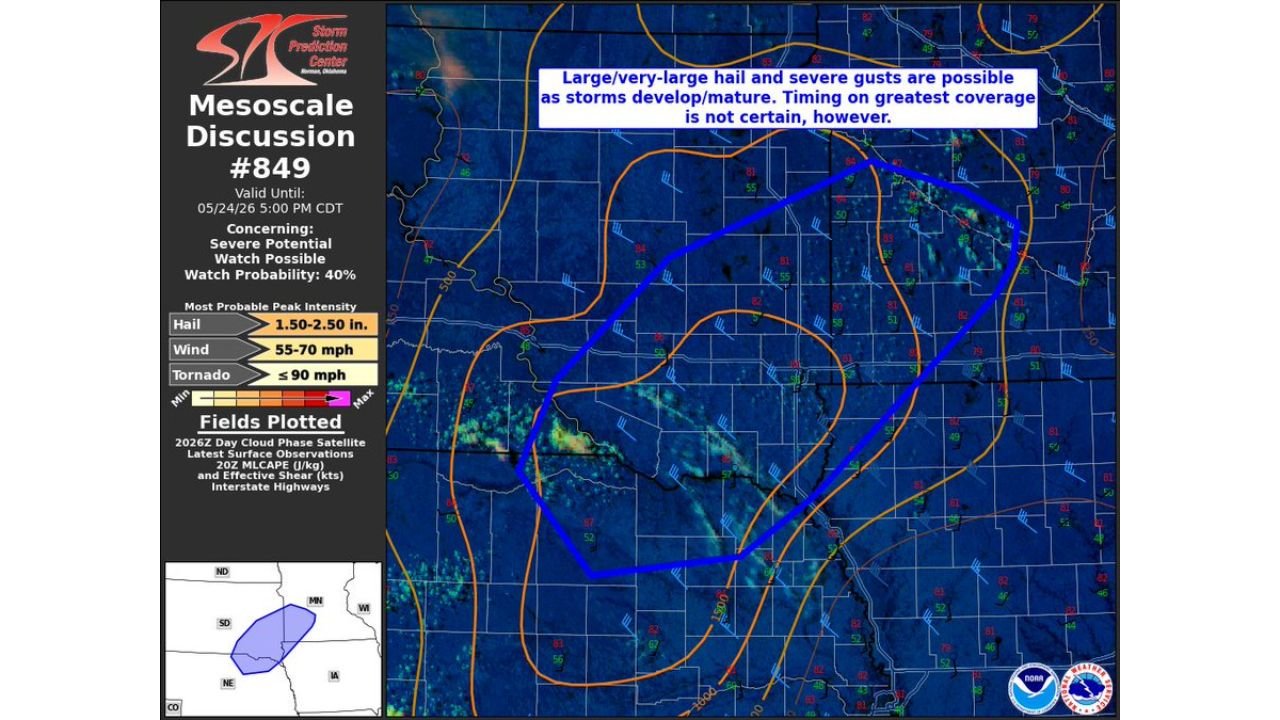
LINCOLN, NEBRASKA — The Storm Prediction Center has issued Mesoscale Discussion 849 at 3:36 PM CDT on May 24, 2026, flagging a significant severe weather threat across northeast Nebraska and southwest Minnesota as storms develop and mature through the afternoon, with a Severe Weather Watch carrying a 40 percent probability already being considered for the region.
SPC Mesoscale Discussion 849 Valid Until 5 PM CDT With 40 Percent Watch Probability
Mesoscale Discussion 849 is valid until 5:00 PM CDT on May 24, 2026 and covers a zone outlined in blue across the Nebraska and Minnesota border region, with the discussion concerning severe potential across areas tagged under the Minnesota, Iowa, South Dakota, and Nebraska weather hashtags.
The Watch Probability sitting at 40 percent signals that SPC forecasters are actively monitoring this corridor for potential upgrade to a formal Severe Thunderstorm Watch if storm development meets the threshold for organized severe weather coverage across the outlined zone.
Hail Up to 1.50 to 2.50 Inches and Winds 55 to 70 MPH Listed as Most Probable Peak Intensity
The most probable peak intensity parameters listed in Mesoscale Discussion 849 are significant across all three primary severe weather categories. Hail is forecast at 1.50 to 2.50 inches, placing potential stones well into the large to very large category capable of causing serious damage to vehicles, roofs, and crops across the impacted region.
Wind gusts are listed at 55 to 70 mph, representing damaging straight-line wind potential that could down trees and power lines across a wide area. Tornado potential is also noted at up to 90 mph, though the primary threats remain hail and damaging winds as storms develop and mature this afternoon.
Timing on Greatest Coverage Remains Uncertain as Storms Develop
SPC forecasters note in the discussion that while large and very large hail along with severe gusts are possible as storms develop and mature, the timing on greatest storm coverage across the outlined zone is not certain at this stage.
Residents across northeast Nebraska and southwest Minnesota should remain weather-aware through the afternoon hours, have multiple ways to receive warnings, and be prepared to take shelter quickly if severe thunderstorm warnings are issued for their area.
Stay with GordonRamsayClub.com for the latest updates.

Leave a Reply