
OKLAHOMA — Severe storms are possible Tuesday May 19 across a large corridor stretching from Oklahoma and Arkansas northeastward through Missouri, Illinois, and Indiana, with large hail, damaging winds, and perhaps a few isolated tornadoes all on the table as high storm fuel CAPE values build across the region through the afternoon and linger into the evening and overnight hours.
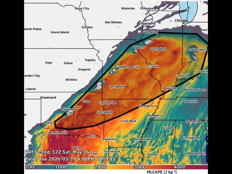
The RRFS model initialized 12Z Saturday May 16 and valid at 4:00 PM CDT Tuesday May 19 shows extremely high MLCAPE values exceeding 4000 to 5000 J per kg across the outlined threat zone, providing abundant energy for significant storm development.
Main Round of Severe Storms Expected Evening Into Overnight With Cold Front Tuesday
While storms could fire ahead of the main cold front during the afternoon hours on Tuesday, forecasters are placing greater confidence in the primary severe weather round arriving later in the evening as the cold front pushes through the outlined threat zone.
The possibility of multiple rounds of storms exists for Tuesday, with an earlier pre-frontal round carrying more uncertainty and the main cold front push in the evening and overnight hours representing the highest confidence and most organized severe weather window of the day.
Communities across the outlined threat zone including Oklahoma City, Tulsa, Wichita Falls, Fort Smith, Fayetteville, Little Rock, Jonesboro, Jefferson City, Springfield, St. Louis, Evansville, Paducah, and Indianapolis all fall within the area of concern for Tuesday’s developing severe weather setup.
Large Hail Damaging Winds and Isolated Tornadoes All Possible Across Threat Zone
Forecasters have identified large hail, damaging winds, and perhaps a few isolated tornadoes as the primary hazards associated with Tuesday’s severe storm potential across the outlined multi-state corridor from Oklahoma through Indiana.
The extremely high CAPE values shown on the RRFS model across the threat zone provide significant energy for storm intensification, supporting the potential for all hazard types to occur simultaneously across different portions of the outlined area during the evening and overnight hours.
The focused region carrying the greatest risk has not yet been narrowed down, with forecasters indicating more details need to be ironed out before a specific highest-risk corridor can be pinpointed within the broader outlined threat area.
Extremely High CAPE Values Signal Dangerous and Unstable Atmosphere Tuesday
The RRFS model valid at 4:00 PM CDT Tuesday May 19 shows a striking area of very high MLCAPE values stretching from Wichita Falls and Oklahoma City northeastward through Tulsa, Little Rock, St. Louis, and Indianapolis, with values reaching 4000 to 5000 J per kg across the core of the outlined threat zone.
CAPE values in this range represent an extremely unstable atmosphere capable of supporting intense and rapidly developing severe thunderstorms, particularly when combined with the wind shear and lift provided by the approaching cold front during the evening hours.
Residents across Oklahoma, Arkansas, Missouri, Illinois, and Indiana are urged to monitor updated forecasts as Tuesday’s severe weather setup continues to come into sharper focus ahead of the cold front arrival. Stay with GordonRamsayClub.com for the latest updates.

Leave a Reply