
EASTERN NEBRASKA — Eastern Nebraska into western Iowa and southwest Minnesota are facing a serious and well-advertised strong tornado threat tomorrow Sunday May 17, as a potent storm system begins to develop and pull deeper moisture and stronger instability northward into an environment of favorable wind shear perfectly suited for supercell development and significant tornado production.
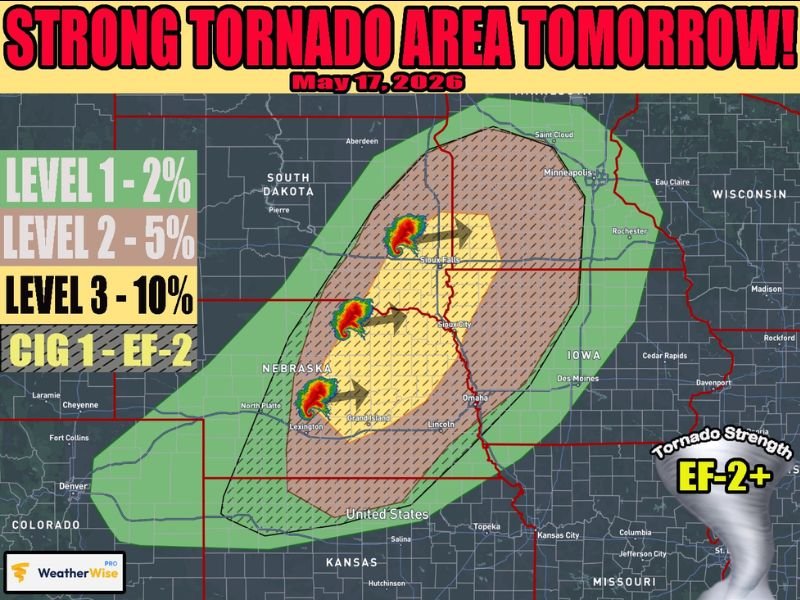
WeatherWise Pro has issued a Level 3 tornado probability at 10 percent with a CIG 1 EF-2 plus tornado strength designation across the core threat zone, making tomorrow one of the most dangerous severe weather days of the spring season for the tri-state region.
Level 3 Core at 10 Percent EF2 Plus Tornado Strength Covering Omaha Sioux City and Lincoln
The most dangerous portion of tomorrow’s tornado threat is concentrated in the yellow Level 3 core zone carrying a 10 percent tornado probability, centered across eastern Nebraska and western Iowa covering communities including Omaha, Lincoln, Grand Island, Sioux City, and Sioux Falls.
The CIG 1 designation confirms that EF-2 or stronger tornadoes are possible within the core threat zone tomorrow, placing this event firmly in the category of a significant and potentially destructive tornado outbreak for the region.
Supercells developing across the favorable wind shear environment tomorrow afternoon are expected to be the primary tornado producers, with deepening moisture and strengthening instability creating textbook conditions for intense and long-track tornado development across the core zone.
Very Large Hail and Intense Straight Line Winds Also Major Threats Sunday May 17
Beyond the significant tornado threat, forecasters are flagging very large hail and intense straight-line winds as additional major hazards with tomorrow’s storm system across eastern Nebraska, western Iowa, and southwest Minnesota.
As the evening and overnight hours progress on Sunday, storms are expected to congeal into an intense bow echo system that will sustain and potentially increase the wind and QLCS tornado potential well into the overnight hours across the region.
The transition from supercells to a bow echo system means the hazard profile shifts as the night progresses, with damaging straight-line winds and embedded QLCS tornadoes becoming the dominant threats after the initial supercell phase during the afternoon and early evening.
Threat Extends Into Far Northern Kansas While South Dakota and Minnesota Also Watching
The tornado and severe weather threat on Sunday May 17 is not limited to eastern Nebraska and western Iowa, with forecasters noting the potential could extend southward into far northern Kansas as well, though storm development in that area carries more uncertainty compared to the core zone further north.
Southwest Minnesota including the Sioux Falls area falls within the Level 2 and Level 3 risk zones for Sunday, placing communities across the southern Minnesota border region under a meaningful tornado and severe weather threat alongside their Nebraska and Iowa neighbors.
A broader Level 1 and Level 2 risk zone extends outward across South Dakota, Minnesota, and Wisconsin, indicating that the overall severe weather footprint for Sunday May 17 spreads well beyond the core EF-2 plus tornado threat zone centered over eastern Nebraska and western Iowa. Stay with GordonRamsayClub.com for the latest updates.

Leave a Reply