
FLORIDA — Brand new storm models are out for Florida this weekend, showing storm chances both Saturday and Sunday across a large portion of the peninsula with the best opportunity for rain arriving during the afternoon and evening hours both days, and Sunday shaping up as the more active and widespread of the two days with greater storm coverage and heavier rainfall potential.
Forecasters are warning that if a heavier storm cell parks itself directly over a location, rainfall totals of 2 to 3 inches or more are possible in a short period of time, giving this weekend a taste of Florida’s upcoming rainy season.
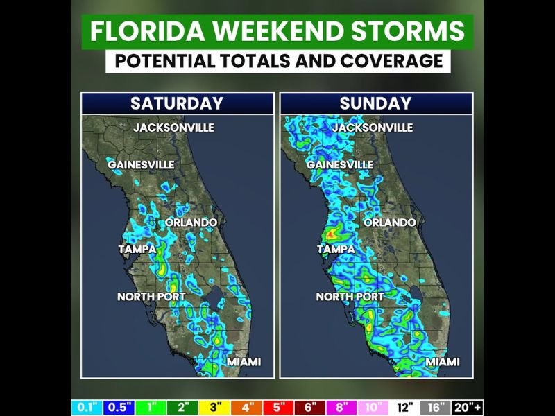
Saturday Brings Scattered Storm Chances Mainly Along Florida Peninsula Afternoon and Evening
Saturday’s storm coverage is shown concentrated primarily along the Florida peninsula with scattered activity visible from Jacksonville southward through Gainesville, Orlando, Tampa, North Port, and into the Miami area during the afternoon and evening hours.
The storm coverage on Saturday is notable but not overwhelming, with the activity remaining scattered in nature meaning not every location across Florida will see rainfall during the day on Saturday.
The best strategy for Saturday is to plan any outdoor activities for the earlier part of the day before the afternoon and evening storm chances increase across the peninsula and heavier cells begin developing.
Sunday Brings Significantly Greater Storm Coverage Especially on Western Side of Peninsula
Sunday stands out as the more active and concerning of the two weekend storm days, with models showing significantly greater storm coverage and more widespread rainfall across Florida compared to Saturday’s scattered activity.
The western side of the Florida peninsula sees notably more storm activity on Sunday, with Tampa, North Port, and surrounding Gulf Coast communities facing a higher coverage of storm cells compared to the eastern portions of the state.
Jacksonville, Gainesville, Orlando, and Miami all also show increased storm activity on Sunday as the broader and more widespread storm pattern engulfs a larger portion of the peninsula during the afternoon and evening hours.
Heavier Cells Could Drop 2 to 3 Plus Inches Quickly in Localized Areas This Weekend
While not every Florida location will see rain this weekend, forecasters are highlighting the localized heavy rainfall threat that comes when a stronger storm cell stalls or parks itself directly over a specific area during the afternoon or evening storm activity.
Any location unfortunate enough to be sitting under a heavier storm cell this weekend could see a quick 2 to 3 inches or more of rainfall in a short period, creating the potential for localized flooding and hazardous driving conditions in the most impacted spots.
Forecasters are describing this weekend’s storm pattern as a taste of Florida’s rainy season, signaling that the more active and stormy summer pattern is beginning to take shape across the Sunshine State heading into late May. Stay with GordonRamsayClub.com for the latest updates.

Leave a Reply