
PENNSYLVANIA — A line of showers and strong storms is forecast to cross much of western and central Pennsylvania this afternoon, driven by enough instability building ahead of an approaching cold front to generate a significant storm corridor with wind gusts of 50 to 60 MPH and possibly quarter-sized hail in the strongest cells. The best timing for the storm line is between 2 PM and 6 PM EDT, with some storms potentially lingering until 9 PM for areas farther to the east.
Storm Line Targeting Western Pennsylvania Including Pittsburgh Between 2 PM and 4 PM
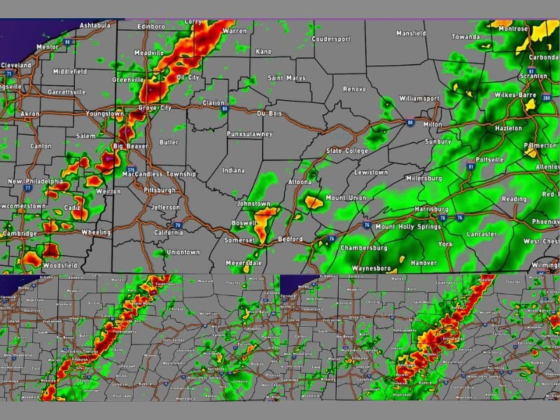
Future simulated radar valid at 2:00 PM EDT shows the heaviest storm activity concentrated across western Pennsylvania, with areas including Pittsburgh, Grove City, Meadville, Greenville, Big Beaver, Butler, and surrounding communities falling into the first and most intense window of storm impact.
The storm line is expected to push through the Pittsburgh corridor during the early afternoon hours before continuing its eastward march into central Pennsylvania through the 4 PM timeframe.
Sufficient morning and early afternoon sunshine is the key ingredient needed to generate enough atmospheric instability ahead of the cold front to fuel the storm line as outlined in the forecast.
50 to 60 MPH Wind Gusts and Quarter Sized Hail Main Threats in Strongest Cells
The primary hazards with this afternoon’s storm line are wind gusts ranging from 50 to 60 MPH and the possibility of quarter-sized hail occurring within the strongest individual cells embedded in the line.
These wind speeds are capable of downing trees and power lines across western and central Pennsylvania, making this a storm event that residents need to take seriously despite the non-severe classification of some of the activity.
Anyone with outdoor plans this afternoon across western and central Pennsylvania is being urged to stay alert for rapidly changing conditions and move indoors immediately when thunder is heard.
Storm Line Pushing Into Central Pennsylvania by 4 PM to 6 PM With Lingering Activity Until 9 PM East
Future radar valid at 4:00 PM EDT shows the storm line advancing deeper into central Pennsylvania, pushing through areas including Du Bois, Punxsutawney, Clarion, Altoona, Johnstown, and State College during the mid-afternoon hours.
By 6:00 PM EDT the storm corridor continues its eastward progression across the state, with some storm activity expected to linger across areas farther to the east until as late as 9 PM before conditions finally clear.
Residents across all of western and central Pennsylvania from Pittsburgh eastward through the Altoona and State College corridors should remain weather aware throughout the entire afternoon and into the early evening hours today. Stay with GordonRamsayClub.com for the latest updates.

Leave a Reply