
IOWA — A major pattern change now officially in the works is set to bring the warmest and potentially hottest temperatures of 2026 to Iowa, Illinois, Wisconsin, and Indiana starting as early as Friday, with 90 degree readings possible this weekend and into early next week — weeks ahead of the average date of June 4 for the region’s first 90 degree temperature of the year.
Forecasters note that the first 90 degree readings of the year have already occurred in May in three of the past four years, making an early 90 degree event far from unprecedented for this time of year.
Extended Spell of 80s Begins Friday With 90 Degrees Possible Saturday and Monday
An extended stretch of 80 degree temperatures is expected to begin by Friday across the region, marking the start of the warmest period since October and a dramatic shift from the cooler spring conditions that have dominated recently.
The best chances for hitting 90 degrees are identified as Saturday and Monday, with forecasters at Mark’s Weather Hub flagging these two days as the peak of the heat event across the Stateline region and surrounding areas.
At the very least residents across Iowa, Illinois, Wisconsin, and Indiana are staring at the warmest temperatures since October, with the hottest readings since August remaining a genuine possibility if model projections verify through the weekend.
Monday Identified as Most Concerning Day With Powder Keg Atmosphere Setup
While the heat this weekend raises eyebrows, forecasters are watching Monday with the greatest level of interest due to a dangerous combination of upper 80s to near 90 degree temperatures and surging dew points expected to converge across the region.
This combination of extreme heat and rapidly increasing moisture will create a powder keg of atmospheric energy that could lead to explosive storm development on Monday if the right ingredients come together during the afternoon and evening hours.
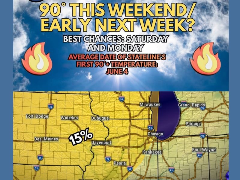
The Storm Prediction Center has already placed the region at a Level 2 out of 5 Slight Risk for severe weather on Monday and Monday night, covering a broad zone that includes Chicago, Milwaukee, Davenport, Dubuque, Waterloo, Des Moines, Fort Dodge, and Fort Wayne with a 15 percent severe weather probability.
Storm Chances Begin Thursday Night and Continue Daily Through at Least Next Tuesday
Beyond the headline heat and Monday’s severe weather risk, storm chances are set to become a daily feature of the forecast beginning Thursday night and continuing through at least next Tuesday as the warmer and more active pattern takes hold across the region.
Forecasters are not concerned about severe weather during the Thursday through Saturday period as humidity will remain low enough to significantly limit atmospheric instability during those initial storm chances.
Moisture increases meaningfully on Sunday, which may allow storms to at least approach severe limits, before Monday’s full combination of extreme heat and surging dew points brings the most significant severe weather potential of the entire pattern change. Stay with GordonRamsayClub.com for the latest updates.

Leave a Reply