
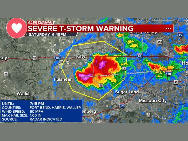
FORT BEND, HARRIS AND WALLER COUNTIES, TEXAS — A Severe Thunderstorm Warning has been issued for Fort Bend, Harris, and Waller counties until 7:15 PM Saturday, May 9, 2026, with residents urged to seek shelter immediately. ABC13 Alert Radar captured the warning at 6:49 PM Saturday, showing an intense storm cell with deep red and purple radar returns concentrated near Katy and Fulshear, tracking toward Sugar Land and the broader southwest Houston metro area. The warning carries a maximum wind speed of 60 mph and hail up to 1 inch in diameter based on radar indicated data.
Seek Shelter Immediately
All residents within Fort Bend, Harris, and Waller counties are urged to seek shelter immediately until the Severe Thunderstorm Warning expires at 7:15 PM Saturday evening. The warning was issued based on radar indicated data showing a storm cell capable of producing 60 mph wind gusts and 1 inch hail moving through the warned counties.
Wind gusts of 60 mph are capable of downing trees and power lines, causing structural damage to buildings, and creating extremely dangerous conditions for anyone caught outdoors during the storm’s passage through the warned area.
Where the Storm Is Tracking
The ABC13 Alert Radar image captured at 6:49 PM Saturday shows the most intense radar returns concentrated directly over the Katy and Fulshear corridor along Interstate 10 and the Westpark Tollway. The storm’s track is pushing the cell toward Sugar Land, Missouri City, and the broader southwest Houston metro area within the warning polygon outlined in yellow on radar.
Communities including Katy, Fulshear, and the areas along the Interstate 10 and Highway 99 corridors are directly in the path of the most intense storm activity as of the 6:49 PM radar snapshot, with the warned area extending across portions of all three listed counties.
Warning Details
The Severe Thunderstorm Warning for Fort Bend, Harris, and Waller counties is valid until 7:15 PM Saturday, May 9, 2026. Maximum wind speeds with the warned storm are listed at 60 mph, with maximum hail size reaching 1.00 inch in diameter. The warning source is radar indicated, meaning the threat was identified through Doppler radar analysis rather than a confirmed ground truth report at the time of issuance.
Residents are urged to move to an interior room away from windows immediately and remain sheltered until the warning expires at 7:15 PM. Stay with GordonRamsayClub.com for the latest updates.

Leave a Reply