
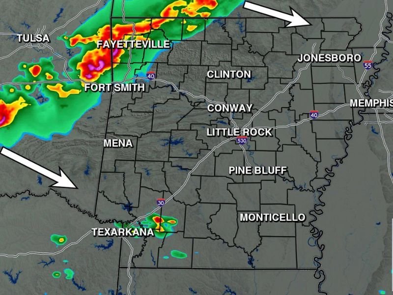
WESTERN AND NORTHWEST ARKANSAS — Incoming storms are expected to push into western and northwest Arkansas this evening, with the Arkansas Weather Network Futurecast showing organized storm activity approaching the Fayetteville and Fort Smith corridor around 8:30 PM Friday. A low end severe weather risk is associated with tonight’s storms, with hail and wind identified as the primary hazards. The tornado risk for Arkansas remains extremely low, near zero, with most of the state expected to largely miss this round of storms as better storm chances arrive Sunday.
What to Expect Tonight
The storm signal for tonight is concentrated across western and northwest Arkansas, with Fayetteville and Fort Smith sitting in the direct path of the incoming storm line based on the latest Arkansas Weather Network Futurecast valid at 8:30 PM Friday. A separate cluster of storm activity is also shown near Texarkana in the far southwest corner of the state.
The storms are expected to be noisy when they move in, but the overall severe weather risk remains at the low end of the scale. Central and eastern Arkansas communities including Little Rock, Conway, Jonesboro, Pine Bluff, and Monticello are expected to largely miss tonight’s storm activity.
Primary Hazards Are Hail and Wind
The two hazards most associated with tonight’s incoming storms across western and northwest Arkansas are hail and wind. While these threats are real and worth monitoring, they remain at the lower end of the severe weather spectrum for this particular event.
The tornado risk across Arkansas tonight is being described as extremely low and near zero, giving residents across the state significant reassurance that tonight’s storms will not carry the more dangerous rotating storm potential seen during recent severe weather events across the region.
Better Storm Chances Coming Sunday
Meteorologists noted that Sunday brings better storm chances across Arkansas compared to tonight’s more limited and geographically confined storm activity. Residents who miss tonight’s storms across central and eastern Arkansas should monitor updated forecasts heading into the weekend as the Sunday storm system comes into better focus over the next 24 to 48 hours.
For tonight, western and northwest Arkansas residents in the Fayetteville and Fort Smith areas should remain weather aware from 8:30 PM onwards as the storm line pushes into the region. Stay with GordonRamsayClub.com for the latest updates.

Leave a Reply