
PENNSYLVANIA — An active Wednesday is ahead for Pennsylvania as a cold front begins crossing the state from west to east, bringing numerous rain showers primarily across the central half of the state along with cooler temperatures statewide. High temperatures on Wednesday will range from the mid 50s across western Pennsylvania up to the upper 60s and 70 degrees in far eastern portions of the state including Philadelphia, where rain will take the longest to arrive.
Temperature Breakdown Across Pennsylvania
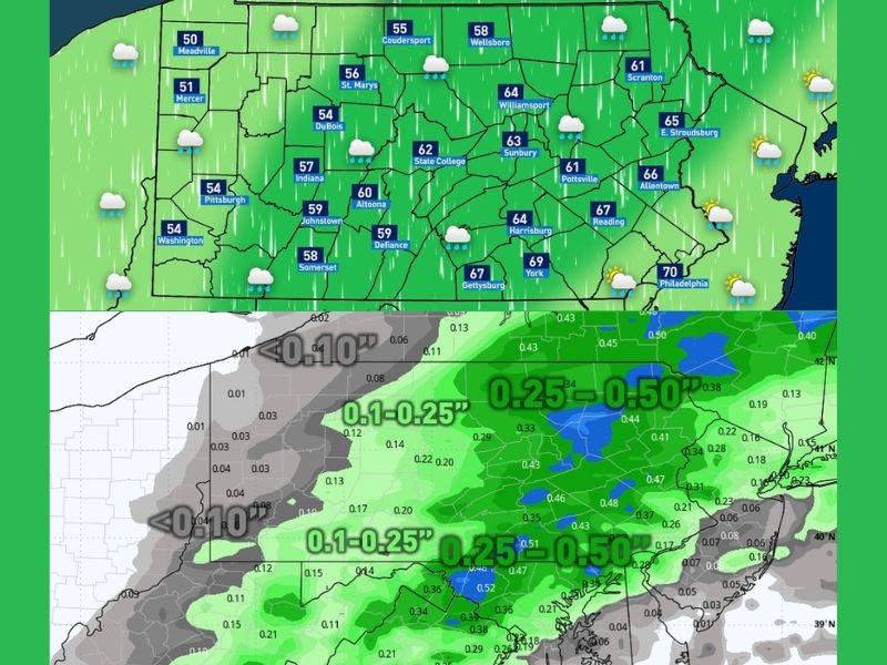
Wednesday’s temperature picture varies significantly from west to east across Pennsylvania. Western communities including Erie, Meadville, Mercer, Pittsburgh, and Washington will see highs stuck in the low to mid 50s ranging from 50 to 54 degrees as the cold front brings its coolest air to the western portion of the state first.
Central Pennsylvania communities including DuBois, Indiana, Altoona, State College, and Johnstown will see highs in the mid to upper 50s, while cities like Harrisburg, York, and Gettysburg climb into the mid to upper 60s reaching 67 to 69 degrees. Philadelphia on the far eastern end of the state will reach a high of 70 degrees, the warmest spot in Pennsylvania on Wednesday as the cold front takes longer to push into the eastern counties.
How Much Rain to Expect
Overall rainfall totals with Wednesday’s cold front will not be particularly significant across the state. Areas receiving the steadiest and most consistent rainfall throughout the day will pick up between 0.25 and 0.50 inches, with those totals concentrated across central and eastern Pennsylvania.
Communities further west and further east from the rainfall maximum zone will see lighter totals generally falling below 0.25 inches, with some far western areas picking up less than 0.10 inches as the cold front pushes through. While the rainfall totals are modest, meteorologists noted the rain is still helpful as Pennsylvania continues progressing through the spring season.
What Is Driving Wednesday’s Weather
A cold front crossing Pennsylvania from west to east is responsible for Wednesday’s rain shower activity and cooler temperature profile across the state. The frontal passage will allow rain showers to develop primarily across the central half of Pennsylvania during the day, with the rain taking the longest to arrive in far eastern communities including Philadelphia and Allentown.
Residents across Pennsylvania should expect a cloudy and showery Wednesday with temperatures running below what would normally be expected for early May across most of the state.
Stay with GordonRamsayClub.com for the latest updates.
Leave a Reply