
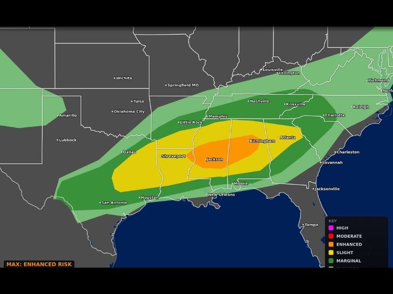
LOUISIANA, MISSISSIPPI AND ALABAMA — An Enhanced Risk of severe weather is in place today, Wednesday May 6, 2026, across Louisiana, Mississippi, and Alabama, with the threat driven primarily by tornadoes, a few of which could be strong. Very large hail and damaging winds will also be possible across the Enhanced Risk zone covering Jackson, Shreveport, and Birmingham as the most dangerous core of today’s severe weather system pushes through the South Central United States.
What Is Driving Today’s Enhanced Risk
Tornadoes are the primary driver behind today’s Enhanced Risk designation across Louisiana, Mississippi, and Alabama. Meteorologists confirmed that a few of the tornadoes that develop today could be strong, meaning EF2 or higher intensity is possible with the right storm development across the most favorable areas within the risk zone.
Very large hail and damaging winds round out the three-pronged severe weather threat for today, making this a multi-hazard event that demands serious preparation and full weather awareness from all residents across the affected region throughout the day and evening.
Areas Inside the Enhanced Risk Zone
The Enhanced Risk orange zone on today’s Max Velocity Weather categorical outlook sits centered over Jackson, Mississippi, and extends through a wide corridor covering much of Louisiana, Mississippi, and Alabama. Shreveport, Birmingham, Mobile, and New Orleans all fall within or immediately adjacent to the Enhanced Risk area, placing millions of residents across three states in the direct path of today’s most dangerous storm potential.
A broader Slight Risk zone surrounds the Enhanced core, covering additional cities including Dallas, Houston, Memphis, Little Rock, Nashville, and Atlanta on the outer edges of today’s severe weather threat area.
How Serious Is an Enhanced Risk
An Enhanced Risk is the third level on the five-tier SPC severe weather scale, sitting above Slight and below Moderate. It indicates a well-organized and widespread severe weather event is expected, with multiple hazards likely to impact a large area simultaneously. Today’s Enhanced Risk driven by strong tornadoes makes this one of the more significant severe weather events of the spring season for the Deep South region.
What Residents Must Do Immediately
All residents across Louisiana, Mississippi, and Alabama within the Enhanced Risk zone are urged to treat today’s threat with the highest level of seriousness. Finalize shelter plans now, ensure weather alert notifications are fully active, and be prepared to move to your safest interior room at ground level the moment a tornado warning is issued for your county today. Stay with GordonRamsayClub.com for the latest updates.

Leave a Reply