
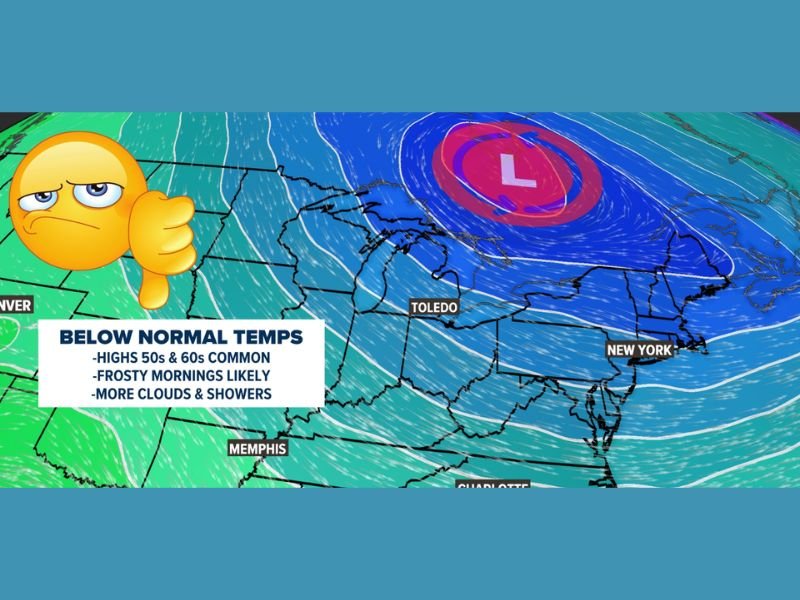
TOLEDO, OHIO / NORTHEAST — A cutoff low pressure system parked over Ontario is set to deliver a prolonged and stubborn cold pattern across the Toledo region and broader Northeast through the end of April and into the first half of May — bringing highs only in the 50s and 60s, recurring frost threats potentially lasting close to Mother’s Day, and significantly more clouds and less sunshine than the region has recently enjoyed.
Cutoff Low Over Ontario Driving the Pattern
The culprit behind the upcoming cold stretch is a cutoff low pressure system sitting over Ontario — one of the most stubborn and slow-moving weather pattern setups a meteorologist can encounter. Unlike typical storm systems that move through and exit within days, cutoff lows become disconnected from the main atmospheric flow and break down far more slowly than models initially project.
WTOL 11 meteorologist noted this pattern has appeared many times over the past 15 years and consistently lingers longer than expected — making this not just a brief cold snap but a genuine extended cool-down that could grip the region for two or more weeks.
No Highs in the 70s for at Least 10 Days
The immediate temperature outlook is straightforward and unwelcome — highs in the 50s and 60s will be the norm across the Toledo area and surrounding region for the foreseeable future. Forecasters confirmed there is not a single day in the 10-day forecast reaching the 70-degree mark.
With the cutoff low expected to break down slowly, warmer and more seasonable weather is not likely to return for at least two or more weeks — pushing any real warmth well into May before the pattern finally shifts.
Frost Threat Persists Potentially Through Mother’s Day
One of the most concerning aspects of this pattern for residents and gardeners alike is the persistent frost threat that accompanies the prolonged cold setup. With overnight temperatures repeatedly dipping to frost-possible levels, the threat is expected to remain in place potentially all the way through Mother’s Day weekend — an unusually late frost risk for the region that could damage newly planted gardens, flowers, and landscaping across the area.
Residents who have already begun spring planting should take protective measures for any frost-sensitive plants and monitor overnight temperature forecasts closely throughout early May.
Overcast Skies and More Clouds Will Dominate
Beyond cold temperatures and frost risk, the third significant impact from this pattern is a dramatic reduction in sunshine. Cutoff low setups are notorious for generating persistent cloud cover — producing overcast days far more frequently than the region has been experiencing through recent weeks.
More clouds, more showers, and significantly less of the sunshine that has characterized recent weather will define the look and feel of the pattern through the first half of May across Toledo, the broader Ohio region, and the Northeast corridor down through New York and Charlotte.
Pattern Expected to Eventually Break — But Slowly
While no weather pattern lasts forever, forecasters are cautioning against any expectation of a quick turnaround. The combination of a slow-moving cutoff low and its historically stubborn breakdown behavior means residents should mentally and practically prepare for a cold, gray, and frosty early May before warmth finally returns. Stay with GordonRamsayClub.com for the latest updates.

Leave a Reply